
Messer, Oklahoma
Messer, Oklahoma | |
|---|---|
UTC-5 (CDT) | |
| GNIS feature ID | 1100629 |
Messer is an unincorporated community located on State Highway 93 in Choctaw County, Oklahoma, United States.[1][2]
A post office was established at Messer, Indian Territory on January 4, 1907. It closed on February 29, 1916.Choctaw Nation.[4]
References
- ^ Official State Highway Map (Map) (2005-2006 ed.). Oklahoma Department of Transportation. § O7.
- ^ U.S. Geological Survey Geographic Names Information System: Messer, Oklahoma
- ^ Shirk, George H. Oklahoma Place Names (Norman: University of Oklahoma, 1965), p. 139.
- ^ Morris, John W. Historical Atlas of Oklahoma (Norman: University of Oklahoma, 1986), plate 38.
Municipalities and communities of Choctaw County, Oklahoma, United States | ||
|---|---|---|
| City | 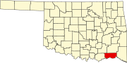 | |
| Towns | ||
| CDPs | ||
| Other unincorporated communities | ||
| Indian reservation | ||
| Footnotes | ‡This populated place also has portions in another county or counties | |
| ||
This Oklahoma state location article is a stub. You can help Wikipedia by expanding it. |