
Mogorjelo
This article needs additional citations for verification. (February 2017) |
| Mogorjelo | |
|---|---|
Могорјело | |
 | |
 | |
| General information | |
| Type | villa rustica |
| Architectural style | Roman |
| Location | Čapljina, Bosnia and Herzegovina |
| Completed | 4th century AD |
| Owner | Bosnia and Herzegovina |
Mogorjelo (Могорјело) is a Roman villa rustica which date back to the early 4th century AD. It is situated on a hill between the rivers Trebižat and Neretva, 5 km south of Čapljina, alongside the road to Gabela in Bosnia and Herzegovina. The area is currently protected by the state as the
National Monument
.
History
An
National Monument.[1]
Tourism
Area is surrounded by a
horse riding club was founded 2004 and attracts over 300,000 visitors per year.[3]
Gallery
-
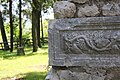 Detail from Mogorjelo
 -
 Mogorjelo ancient Roman suburban Villa Rustica from the 4th century, near Čapljina, Bosnia and Herzegovina
 -
 Mogorjelo ancient Roman suburban Villa Rustica from the 4th century, near Čapljina, Bosnia and Herzegovina
 -
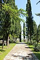 Mogorjelo St.


References
- ^ a b c d e f g h i j k "Commission to preserve national monuments". Archived from the original on 2009-08-14. Retrieved 2009-03-17.
- ^ "MOGORJELO Villa - My Bosnia & Herzegovina". Archived from the original on 2013-02-22. Retrieved 2012-07-05.
- ^ "MOGORJELO - Horseback riding - Amico Tours". Archived from the original on 2012-07-18. Retrieved 2012-07-05.