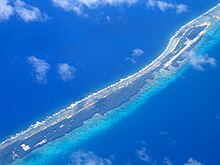
Moruroa
above water) | |
| Length | 28 km (17.4 mi) |
|---|---|
| Width | 11 km (6.8 mi) |
| Administration | |
France | |
| Overseas collectivity | French Polynesia |
| Administrative subdivision | Tuamotus |
| Commune | Tureia |
| Demographics | |
| Population | Uninhabited[1] (2012) |
Moruroa (Mururoa, Mururura), also historically known as Aopuni,
History

The first recorded visit this atoll was Commander Philip Carteret on HMS Swallow in 1767, just a few days after he had discovered Pitcairn Island. Carteret named Mururoa "Bishop of Osnaburgh Island".[3] In 1792, the British whaler Matilda was wrecked here, and it became known as Matilda's Rocks.[3] Frederick William Beechey visited it in 1826.[3]
Early European explorers found that the atoll was not continuously inhabited. In 1826 Beechey found it empty. A visit in 1832 found "dwellings but no inhabitants".[4] A visiting ship in 1834 killed all but three of the inhabitants it found there, and it was unclaimed in 1847.[4] It was briefly inhabited by copra workers in the late nineteenth century, and again from 1942 to 1943 and 1950–52, but has had no permanent inhabitation since.[4]
French nuclear weapons testing

Mururoa, and its sister atoll Fangataufa, were the site of extensive
Despite objections from some 30 members of the


France abandoned atmospheric nuclear testing in 1974 and moved to underground testing in the midst of intense world pressure which was sparked by the
French president
The test site at Mururoa was dismantled following France's last nuclear test to date, which took place on 27 January 1996 on Fangataufa. In total, 181 explosions took place at Moruroa, 41 of which were atmospheric.[8] However, the total number has been variously reported: nuclear scientists working at the site claim 175 explosions in total took place in the Pacific.[11]
Aftermath
As of October 2005, it is still prohibited to visit Moruroa, according to the
Monitoring
A report from 2012 suggested that only 11 of the 20 monitoring system sensors are actually functional, which could mean the atoll could potentially collapse without forewarning of the monitoring system.[13]
In February 2021, the French National Institute of Health and Medical Research INSERM published a report entitled "Nuclear tests and health - Consequences in French Polynesia".[14] The objective of this study was to establish an assessment of the available international scientific knowledge on the health consequences of the atmospheric nuclear tests conducted by France in French Polynesia, on the general population and former civilian and military workers.[14]
See also
- Bengt Danielsson, a member of the Kon-Tiki crew; an outspoken critic of nuclear testing
- Effects of French nuclear testing
- France and weapons of mass destruction
- List of nuclear weapons tests by France
- New Zealand nuclear-free zone
References
- ^ "Population". Institut de la statistique de la Polynésie française. Archived from the original on 29 March 2020. Retrieved 9 October 2014.
- ^ Young, J.L. (1899). "Names of the Paumotu Islands, with the old names so far as they are known". Journal of the Polynesian Society. 8 (4): 264–268. Retrieved 7 January 2015.
- ^ ISBN 978-0-207-16114-8. Retrieved 22 July 2012.
- ^ a b c "The Radiological Situation at the Atolls of Mururoa and Fangataufa" (PDF). IAEA. 1998. pp. 23–24. Retrieved 25 February 2021.
- ^ ISBN 978-1-56691-172-6. Retrieved 22 July 2012.
- ISBN 978-1-876175-05-4. Retrieved 22 July 2012.
- ^ "Environmental Effects of French Nuclear Testing". Retrieved 25 February 2021.
- ^ ISBN 978-1-56691-411-6. Retrieved 22 July 2012.
- ^ ISBN 978-1-59486-106-2. Retrieved 22 July 2012.
- ^ ISBN 9780473010089. Retrieved 22 July 2012.
- ^ a b "Mururoa. How safe are the French tests?". Australian Broadcasting Corporation. Retrieved 22 July 2012.
- ^ "High levels of radioactive contamination in French Polynesia". NZ Herald. Retrieved 3 April 2022.
- ^ "NUCLEAIRE - Moruroa réclame 'le droit de savoir'". La Depeche (in French). 1 April 2012. Retrieved 22 July 2012.
- ^ ISBN 978-2-7598-2472-4. Archived from the original(PDF) on 6 March 2021. Retrieved 6 March 2021.
Further reading
- Wright, Gerry (2015). Operation Pilaster: The Story of the Voyages by the Frigates HMNZ Ships Otago and Canterbury, Supported by the Australian Naval Tanker, HMAS Supply, to Protest Against the French Atmospheric Nuclear Tests at Mururoa Atoll in 1973. Auckland: Gerry Wright. ISBN 9780473327712.
External links
- (in French) Archives sur le Centre d'Expérimentations Nucléaires du Pacifique (C.E.P.) à Mururoa, Hao et Fangataufa
- Centre de Documentation et de Recherche sur la Paix et les Conflits
- An Australian Broadcasting Corporation interview with various nuclear scientists on Moruroa
- Classification of the French Polynesian atolls by Salvat (1985)
- France finally agrees to pay damages to nuclear test victims
- Mururoa Veterans
