
Mount Fumaiolo
This article needs additional citations for verification. (September 2013) |
| Mount Fumaiolo | |
|---|---|
 | |
| Highest point | |
| Elevation | 1,407 m (4,616 ft) |
| Prominence | 488 m (1,601 ft) |
| Coordinates | 43°47′15.20″N 12°4′33.95″E / 43.7875556°N 12.0760972°E |
| Geography | |
 Mount Fumaiolo | |
| Parent range | Apennine Mountains |
Mount Fumaiolo (
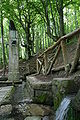
The Springs of the river Tiber
The source of the
Emilia Romagna region. In 1927, under Benito Mussolini's dictatorship, an antique marble column from the Roman Forum was placed on the spot, with an inscription on it: QUI NASCE IL FIUME SACRO AI DESTINI DI ROMA ("Here springs the river / sacred to the destinies of Rome"), to mark the association of the Fascist regime with the ancient Roman empire. A Roman eagle
stands on the top of the column, and three wolf heads, each holding a ring in its mouth, are visible on the sides.
In its first kilometers the Tiber runs through Emilia Romagna; then it enters Adige, and the second in volume of water discharge, after the Po.[1]
-
 The source of the Tiber
 -
 The source of the Tiber (side view)
 -
 Benito Mussolini's inscription
 -
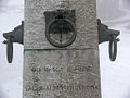 The inscription and ornaments
 -
 The eagle on the column


See also
References
- ^ a b "Mount Fumaiolo: source of the Tiber river - Le Ceregne Tuscany Farmhouse". Tuscanyfarmholiday.net. Retrieved 2013-09-28.
- ^ "Fumaiolo". Turismo.fc.it. Archived from the original on 2012-02-18. Retrieved 2013-09-28.
- ^ a b "Tiber Springs - Mount Fumaiolo". Turismo.fc.it. Retrieved 2013-09-28.
| Authority control databases: Geographic |
|---|