
Moygoish
Moygoish
Uí Mhac gCuais | |
|---|---|
IST (WEST)) | |
| Irish Grid Reference | N334647 |
Moygoish (
Fore (to the north–east), Moyashel and Magheradernon (to the south–east) and Rathconrath
to the south–west.
Geography
Moygoish has an area of 40,320.4 acres (163.171 km2).[2]
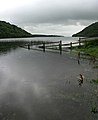
The barony contains the western end of the large lake,
River Inny flows through Lough Iron, then near the small village of Rathowen, before it connects to the River Shannon
.
The
also passes through the barony.The
Longford town
.
Civil parishes of the barony
This tableEcclesiastical parish).
| Name in English | Name in Irish |
|---|---|
| Kilbixy | Cill Bhiscí |
| Kilmacnevan | Cill Mhic Naomháin |
| Rathaspick | Ráth Easpaig |
| Russagh | An Rosach |
| Street | An tSráid |
| Templeoran | Teampall Odhráin |
Towns, villages and townlands
- Ballynacargy, or Ballinacarrigy, a small village on the R393 regional road.
- Rathowen (Irish: Ráth Eoghain, meaning "Eoghan's Ringfort"), a small village on the N4 national primary route.
- Street, a village on the L1927 local road.
There are 115 townlands in the barony of Moygoish.[2]
Places of interest
- Tristernagh Abbey, also known as the Priory of Kilbixy, is a ruined Augustinian priory founded in 1192, situated on the shores of Lough Iron.
-
-
 Royal Canalsouth–east of Ballynacargy


References
- ^ Barony of Moygoish The Placenames Database of Ireland. Retrieved 23 May 2015
- ^ a b c Moygoishtownlands.ie Retrieved 23 May 2015
- ^ Irish Rail Printable Timetables Archived 2 April 2019 at the Wayback Machine irishrail.ie Retrieved 23 May 2015
- ^ Civil parishes of the barony of Moygoish. The Placenames Database of Ireland. Retrieved 7 June 2015
External links
- Map of Moygoish at openstreetmap.org
- Barony of Moygoish, County Westmeath at townlands.ie
