
Muscota Marsh
| Muscota Marsh | |
|---|---|
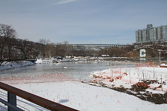
 Muscota Marsh, with freshwater wetland covered by snow in foreground | |
 | |
| Type | Urban park |
| Location | Manhattan, New York City |
| Coordinates | 40°52′24″N 73°55′06″W / 40.873294°N 73.918376°W |
| Area | 1 acre (0.40 ha) |
| Operated by | New York City Department of Parks and Recreation |
| Status | Open all year |
Muscota Marsh is a one-acre public park in the
"Muscota" comes from a
Opened to the public in January 2014, the park was constructed by Columbia University as part of a deal to construct the new Campbell Sports Center within its adjacent athletics complex. It was designed by James Corner Field Operations, which also worked on Manhattan's High Line. It is cooperatively administered by the New York City Department of Parks and Recreation and Columbia, with the university providing maintenance and security.[4]
Gallery
-
 Salt marsh area, with small flags to discourage Canada geese from eating newly planted Spartina grasses.
 -
 View from park with Inwood Hill Park, Henry Hudson Bridge, N.J. Palisades, andBronx.
 -
 Boat dock and deck covered in snow, with Columbia "C" on opposite bank.


References
Notes
- ^ a b "Muscota Marsh". New York City Department of Parks and Recreation. Retrieved February 10, 2014.
- OCLC 7553276.
- ^ Pirsson, J.W. (1889). The Dutch Grants, Harlem Patents and Tidal Creeks: The Law Applicable to Those Subjects Examined and Stated. L. K. Strouse. p. 1. Retrieved July 29, 2019.
- ^ ISSN 0362-4331. Retrieved December 16, 2019.
External links
 Media related to Muscota Marsh at Wikimedia Commons
Manhattan is the most popular city in New York City. This diverse city is made up of 64 Neighborhoods and 4 primary sections. Manhattan, originality named ‘Mannahatta’ was inhabited by the Lenape people. Later in 1664 the British took control of the colony and named it New York. The city is made ups of 4 primary sectors Downtown, Midtown, Uptown, and Harlem and The Heights. The areas south of 14th Street are considered part of Downtown. Midtown extends from 14th Street to the southern border of Central Park at 59th Street. Uptown is 60th to 116th Streets and north of 116th is considered Harlem.[1] In these 4 primary sections are 64 neighborhoods including; Alphabet City, Battery Park City, Bloomingdale District, Bowery, Carnegie Hill, Central Park, Chelsea, Chinatown, Civic Center, East Harlem, East Village, Financial District, Fort George, Garment District, Governors Island, Gramercy, Greenwich Village, Hamilton Heights, Harlem, Hell’s Kitchen (Clinton), The Highline, Hudson Heights, Hudson Square, Hudson Yards, Inwood, Kips Bay, Lenox Hill, Lincoln Square, Little Italy/Nolita, Lower East Side, Manhattan Valley, Manhattanville, Marble Hill, Meatpacking District, Metropolitan Hill, Midtown, Midtown East, Midtown South, Morningside heights, Murray Hill, Noho, Nomad, Randall’s Island, Roosevelt Island, Rose Hill, Soho, South Street Seaport, Spanish Harlem (El Barrio), Stuyvesant Town, Sugar Hill, Sutton Place, Theater District (Times Square), Tribeca, Tudor City, Turtle Bay, Two Bridges, Union Square, Upper East Side, Upper West Side, Washington Heights, West Village, World Trade Center, and Yorkville.[2]
Downtown Manhattan are known as the areas below 14th Street and commonly well known as the business hub of New York. This includes some well known areas like Wall Street, the Brooklyn Bride entrance, Financial District, World Trade Center cite, and historic Seaport District. This was the original start of the city back in 1624 and is the southern part of the island. This is the oldest part of the city with arrays of architecture, soaring skyscrapers, and historical areas.[3] The NYTimes has a walking tour of this area that can be found here: https://archive.nytimes.com/www.nytimes.com/ref/travel/TOUR-LM.html
Midtown Manhattan, the tourist hub of the city, is filled with everything that makes the city what it is. This section is known as the areas between 14th street and the south boarder of Central Park on 59th street. In 1807 the city planners of the city began to create a grid system and was finalized 4 years later for the plans to create Midtown Manhattan. Some famous landmarks/areas in Midtown include; Museum of Modern Art (MOMA), Empire State Building, Bryant Park, Times Square, Madison Square Garden, and Carnegie Hall.[4] The NYTimes has a walking tour of this area that can be found here: https://archive.nytimes.com/www.nytimes.com/ref/travel/TOUR-MID.html?scp=1&sq=Magnificent%2520Tree&st=cse
Uptown Manhattan is located from the south end of Central Park to to not most point of it spanning across 60th street to 116th street. This specific area of Manhattan is one of the most sought after places to reside in with neighborhoods such as the Upper East Side and the Upper West Side. Along the east side of the island is also a small island, Roosevelt Island, commonly used in the 19th century for prisons, institutions, and rehabilitation.[5] The NYTimes has a walking tour of the Upper West Side that can be found here: https://archive.nytimes.com/www.nytimes.com/ref/travel/TOUR-WS.html?ref=untapped-new-york.ghost.io
Harlem and The Heights are all of the neighborhoods in Manhattan above 116th street. Harlem is known internationally as the Black Mecca of the world, but has been home to the Dutch, Irish, German, Italian, and Jewish. This was originally farmland when it was first settled back in 1658 and undeveloped for about 200 years. The IRT subway line was finished in 1904 and people assumed this would make Harlem desirable to relocate to. With such easy access to the city, many developers built apartments and home anticipating the move from lower to upper Manhattan. Unfortunately, this was an over speculations and most places were left unsold. A real estate agent, Philip A. Payton, approach many of the landlords with proposition to have black families move into these home, eventually creating ‘Black Harlem’ in the early 1900’s. During this time the Harlem boomed with culture and artistic expression also known as the ‘Harlem Renaissance’ in the 1920’s.[6] Here is a short walk through of Harlem from the NYTimes: https://www.nytimes.com/2020/08/20/arts/design/harlem-virtual-tour.html
Overall, Manhattan is a very large city spanning over 13 miles long[7] of city, history, and opportunity. Spanning through 4 primary sections, this city offers thousands of places to visit and discover.
- ^ https://www.gobeyondthesquare.com/post/manhattan-uptown-downtown-and-the-places-in-between-2
- ^ https://www.cityneighborhoods.nyc/manhattan-neighborhoods
- ^ https://infographicworld.com/downtown-manhattan-the-little-known-history-of-downtown-manhattan/
- ^ https://thedisabilityguys.com/the-history-of-midtown-manhattan/
- ^ https://rioc.ny.gov/161/Island-History
- ^ https://www.vagelos.columbia.edu/education/residencies-fellowships-and-training/harlem-hospital-center/about-harlem-hospital-center/our-history/harlem-and-new-york-city#:~:text=Harlem%20is%20known%20internationally%20as,territory%20for%20approximately%20200%20years.
- ^ https://www.nyctourism.com/visitor-info/#:~:text=Manhattan%20Island%20is%20roughly%2013.4,across%20at%20its%20widest%20point.