
Nørre Stenbro
Nørre Stenbro | |
|---|---|
Neighborhood | |
Kingdom of Denmark | |
| Regions of Denmark | Central Denmark Region |
| Municipality | Aarhus Municipality |
| District | Aarhus C |
| Postal code | 8000 |
Nørre Stenbro is a small neighborhood in the city of
The
The name
The name Nørre Stenbro is a recent invention from 1971 when the local residents organization was established and adopted it. The name is believed to be a reference to the colloquial term "Stentoften" previously used to reference the area beyond Nørreport.[1]
History

Nørre Stenbro is located at the inner northern edge of the 1850s Aarhus city limits. Aarhus was at the time walled as
The city walls coming down coincided with the
Nørre Stenbro developed as a working-class neighborhood in the late 19th through early 20th centuries.
Gallery
- Nørre Stenbro
-
 Nørreport, a major traffic gate to the Port of Aarhus and the new developing neighbourhood of Aarhus Docklands.
 -
 Le Basilic, one of many restaurants in the long street of Mejlgade.
 -
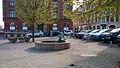 Mejlborg Torvet, a small cobbled square including the bronze fountain of Ålefangeren (The Eel-catcher).
 -
 Østbanetorvet, a small square and transport hub.
 -
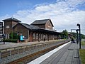 Østbanetorvet Station, a local train station at Østbanetorvet.
 -
 One of many extravagant grave monuments on the large Nordre Cemetery.


- Skovvejskvarteret
-
 The street of Skovvejen and the surrounding quarter of Skovvejskvarteret also forms part of the registration.
 -
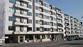
 Klintegaarden, a modernist apartment complex overlooking the Bay of Aarhus (built in 1935).
 -
 The roadside facade of Klintegaarden.
 -
 From the atrium garden at Klintegaarden.


References
- ^ ISBN 87-87926-06-7.
- ISBN 87-87926-06-7. Archived from the originalon 2016-03-04. Retrieved 2015-08-14.
- ISBN 87-87926-06-7.
- ISBN 87-87926-06-7.
- ^ "Sag:Raas Gaard" (in Danish). Danish Department of Culture. Retrieved 14 August 2015.
- ^ "Sag:Klintegaarden" (in Danish). Danish Department of Culture. Retrieved 14 August 2015.
