Oakley Square
Appearance


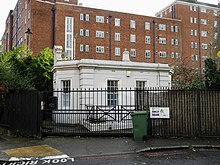
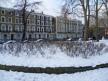
Oakley Square is a crescent-shaped garden square in Somers Town in Central London, close to Mornington Crescent and Camden Town. It is located in the London Borough of Camden and runs roughly northeastwards from Eversholt Street meeting with the southern end of Camden Street on its eastern side.
It was originally part of the
From 1854 the square was home to the
vicarage still survives, which is also now Grade II listed.[6]
References
- ^ Bebbington p.237
- ^ Drew p.4
- ^ "OAKLEY SQUARE GARDENS LODGE, Non Civil Parish – 1322082 | Historic England". historicengland.org.uk.
- ^ "NUMBERS 53–57 AND ATTACHED RAILINGS, Non Civil Parish – 1322080 | Historic England". historicengland.org.uk.
- ^ "NUMBERS 58–70 AND ATTACHED RAILINGS, Non Civil Parish – 1322081 | Historic England". historicengland.org.uk.
- ^ "THE OLD VICARAGE AND ATTACHED RAILINGS, GATE AND WALL, Non Civil Parish – 1322083 | Historic England". historicengland.org.uk.
Bibliography
- Bebbington, Gillian. London Street Names. Batsford, 1972.
- Cockburn, J. S., King, H. P. F. & McDonnell, K. G. T. & A History of the County of Middlesex. Institute of Historical Research, 1989.
- Cherry, Bridget & Pevsner, Nikolaus. London 3: North West. Yale University Press, 2002.
- Drew, Alison. Between Empire and Revolution: A Life of Sidney Bunting, 1873–1936. Routledge, 2015.
51°32′03″N 0°08′10″W / 51.53417°N 0.13611°W
