
One Eye Peak
| One Eye Peak | |
|---|---|
 Old One Eye of Princess Louisa Inlet | |
| Highest point | |
| Prominence | Princess Louise Inlet, East of Queens Reach, New Westminster Land District |
| Coordinates | 50°12′45.00″N 123°49′1.00″W / 50.2125000°N 123.8169444°W |
| Geography | |
| Location | Princess Louisa Inlet , British Columbia, Canada |
| Parent range | Pacific Ranges |
| Topo map | NTS 92J4 Princess Louisa Inlet |
One Eye Peak is a
Sechelt First Nation translation "TUHK-OHSS" referring to "Old One Eye" and is the protector of the inlet.[2]
External links
- CM_C2308 Fraser River to N.E.Pt. of Texada Island including Howe Sound and Jervis Inlet 'Annotated' 1863.02.16 1865.08[clarification needed]
Gallery
- One Eye Peak Gallery
-
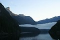
 One Eye Peak overlooking the entrance to Princess Louisa Inlet and the Malibu Club.
 -
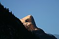 One Eye Peak shining in the Alpine glow of dusk
 -
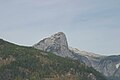
 One Eye Peak at dawn
 -
 One Eye Peak overlooking Princess Louisa Inlet
 -
 One Eye and the Malibu Totem
 -
 Old One Eye and Sun Peaks the mountains of Princess Louisa Inlet
 -
 One Eye during the summer of 2006 - down to the bed rock


References
- ISBN 0972025502.
- ISBN 1-55017-017-1.