
Osteiner Hof

The Osteiner Hof ("Court of Ostein") is one of several
Characteristic features for this building are the three round protrusions (
The von Osteins, a dynasty of counts, were not able to make use of the mansion for very long. After the left bank of the Rhine was occupied by French Revolutionary armies, the mansion was appropriated by the state, and in 1798 it became the seat of a newly created département of France, Mont-Tonnerre.
The building continued to be used as a seat of government after the Napoleonic era, even gaining the nickname Gouvernement during the years 1854-1859, while emperor-to-be
In 1914, then-military governor General Hugo von Kathen announced the start of World War I to the Mainz populace from the balcony of the Osteiner Hof. The mansion was destroyed by fire during World War II, but was restored in 1947-1948. From 1958 until 2014, the Osteiner Hof was in use by the Bundeswehr as military headquarters and officers' mess.
The Osteiner Hof plays an important part in the local carnival traditions. Every year, on 11 November at 11 past 11, the start of the carnival season is proclaimed from the balcony of the mansion.
-
 The centralrisaliton the facade
 -
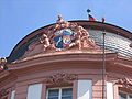 Coat of arms of the Ostein dynasty, framing the centralrisaliton the facade
 -
 The Osteiner Hof with a view of theSt. Stephan's Church


Sources
49°59′50″N 8°16′5″E / 49.99722°N 8.26806°E
This article about a palace in Germany is a stub. You can help Wikipedia by expanding it. |