Pa Sak River
This article needs additional citations for verification. (January 2021) |
| Pa Sak River (แม่น้ำป่าสัก) | |
|---|---|
 The Pa Sak River flowing east of Ayuttaya's old city | |
| Location | |
| Country | Thailand |
| Physical characteristics | |
| Source | |
| • location | Phetchabun Mountains |
| Mouth | |
• location | Chao Phraya River at Ayutthaya Island |
| Length | 513 km (319 mi) |
| Basin size | 16,291 km2 (6,290 sq mi) |
| Discharge | |
| • average | 2.4 km3 (0.58 cu mi)/yr |

The Pa Sak River (
Ayutthaya
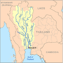
near Phet Fortress. It has a length of 513 km (319 mi) and drains a watershed of 16,291 km2 (6,290 sq mi). The annual discharge is 2.4 km3 (0.58 cu mi).
The valley of the Pa Sak through the
Pa Sak Cholasit Dam
(เขื่อนป่าสักชลสิทธิ์) in Lopburi Province was built. The 4,860-meter (15,940 ft) wide and 36.5-meter (120 ft) high dam retains 0.785 km3 (0.188 cu mi) of water. The dam also supplies about 6.7 MW of electricity.
Tributaries
Tributaries of the Pa Sak include the
Khlong Wang Chomphu, Khlong Huai Na, Huai Nam Chun, Huai Nam Duk, Huai Khon Kaen, Huai Yai, Khlong Saduang Yai, Khlong Ban Bong, Khlong Tarang, and Lam Phaya Klang
.
Pa Sak Basin
The Pa Sak drains an area of 16,291 square kilometres (6,290 sq mi).[1] The Pa Sak Basin is part of the Chao Phraya watershed.
References
- ^ "Basins of Thailand". Retrieved 2008-03-29.[dead link]
External links
14°21′51″N 100°34′48″E / 14.36417°N 100.58000°E
