
Papagou
Papagou
Παπάγου | |
|---|---|
UTC+3 (EEST) | |
| Postal code | 156 69 |
| Area code(s) | 210 65 |
| Vehicle registration | I, Y, Z |
Papagou (
Second World War and the Greek Civil War, before becoming Prime Minister of Greece. The Greek Ministry of National Defense
is located in town.
Papagou was part of the municipality of
Kallikratis Plan.[3]
Geography
Papagou is situated west of the Hymettus mountains, 6 km east of Athens city centre. The municipal unit has an area of 3.375 km2.[4] The eastern beltway Motorway 64 passes southeast of the town. Adjacent suburbs are Cholargos to the northeast and Zografou to the southwest.
Sports
Papagou B.C. is the professional basketball team of Papagou.
Historical population
| Year | Population |
|---|---|
| 1981 | 12,553 |
| 1991 | 13,974 |
| 2001 | 13,207 |
| 2011 | 13,699 |
| 2021 | 13,962 |
Gallery
-
 The bust of Alexandros Papagos in front of the town hall
 -
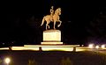 Papagos statue
 -
 Cultural Hall of Papagou.
 -
 Architecture of Papagou.
 -
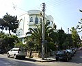 Neighbourhood
 -
 Local park.
 -
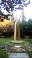 A monument in Papagou park.
 -
 Municipal Theatre of Papagou.


See also
- List of municipalities of Attica
References
- ^ "Αποτελέσματα Απογραφής Πληθυσμού - Κατοικιών 2021, Μόνιμος Πληθυσμός κατά οικισμό" [Results of the 2021 Population - Housing Census, Permanent population by settlement] (in Greek). Hellenic Statistical Authority. 29 March 2024.
- ^ "EETAA local government changes". Retrieved 28 June 2020.
- ^ "ΦΕΚ B 1292/2010, Kallikratis reform municipalities" (in Greek). Government Gazette.
- ^ "Population & housing census 2001 (incl. area and average elevation)" (PDF) (in Greek). National Statistical Service of Greece.
External links
- Official website (in Greek)