
Passage du Gois

The Passage du Gois (French pronunciation: high tide. A road runs along the causeway.
Every year, a foot race – the Foulées du Gois – is held across it, starting at the onset of high tide.[2]
Tour de France
The Passage du Gois was used in Stage 2 of the 1999 Tour de France bicycle race. It proved to be divisive due to a crash caused by the slippery surface. The crash created a six-minute split in the peloton which ended the hopes of many favourites to win the race, including Alex Zülle, who would eventually finish second overall.[3]
The Passage du Gois was used again in the 2011 race, as the starting point of the first stage.[4]
-
 Flooded causeway (island side).
 -
 Tide tables
 -
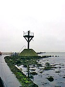 Beacon
 -
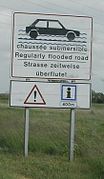 Warning notice
 -
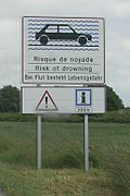 Risk of drowning


See also
- Île de Noirmoutier
- The Broomway, a similar causeway to Foulness Island in Essex, England
Wikimedia Commons has media related to Passage du Gois.
46°55′51″N 2°07′34″W / 46.93083°N 2.12611°W
References
- ^ "Le Passage du Gois". Beauvoir sur Mer (in French). Mairie de Beauvoir sur Mer. Archived from the original on 2015-07-06. Retrieved 2015-07-07.
- ^ "Passage du Gois". Retrieved 20 September 2021.
- ^ "1999 Tour de France stage two: Passage du Gois causes chaos". Cycling Weekly. 30 June 2011. Retrieved 20 September 2021.
- ^ "Passage du Gois, team time trial back for 2011 Tour". VeloNews. Retrieved 20 September 2021.