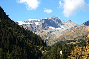
Piz Sardona
This article needs additional citations for verification. (December 2021) |
| Piz Sardona | |
|---|---|
| Surenstock | |
 Piz Sardona from the Calfeisen valley (east side) | |
| Highest point | |
| Elevation | 3,056 m (10,026 ft) |
| Prominence | 113 m (371 ft)[1] |
| Parent peak | Piz Segnas |
| Coordinates | 46°55′22.2″N 9°15′5.4″E / 46.922833°N 9.251500°E |
| Geography | |
| Location | Graubünden) |
| Parent range | Glarus Alps |
Piz Sardona (or Surenstock) is a
Graubünden
. The summit itself is the northernmost point above 3,000 metres in Switzerland.
The massif is covered by a few small glaciers, the Sardonagletscher lying near the summit on the east side.
Piz Sardona is in the Glarus thrust area, a geologic UNESCO world heritage site, named "Swiss Tectonic Arena Sardona".
The
.
