
Planina Cave

Planina Cave (
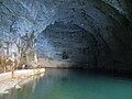
Rak River, flowing to Planina Cave through Weaver Cave from Rak Škocjan. This is one of the largest confluences of subterranean rivers in Europe.[1]
Entrance into the cave is at the southwestern part of Planina Polje in the gable end valley below 65 high rocks. The length of the cave is 6,656 m (21,837 ft).[2] It has been shown by water tracing that there is a connection between the systems of Planina Cave and Postojna Cave, and the administration of Postojna Cave estimates the connection will also be explored by cavers. The length of the joint system would be over 31 kilometres (19 mi).[3]
Geographical data
- WGS 84)
- longitude: 14°14'45" E
- elevation: 453 m (1,486 ft)
- length of the cave: 6,656 m (21,837 ft)
- subterranean depth: −65 m (−213 ft)
Gallery
-
 Inside the mouth of Planina Cave
 -
 The Unica River emerging from the cave
 -
A video of the Unica emerging from the cave


References
- ^ Kogovšek, Janja; Petrič, Metka; Zupan Hajna, Nadja; Pipan, Tanja. "Planinska jama" [Planina Cave]. In Šmid Hribar, Mateja; Golež, Gregor; Podjed, Dan; Kladnik, Drago; Erhartič, Bojan; Pavlin, Primož; Ines, Jerele (eds.). Enciklopedija naravne in kulturne dediščine na Slovenskem [Encyclopedia of Natural and Cultural Heritage in Slovenia] (in Slovenian). Retrieved 17 May 2012.
- ^ "Planinska jama" [Planina Cave]. e-kataster jam (in Slovenian). Retrieved 25 February 2013.
- ^ "V Postojnski jami odkrili nov podvodni rov" [A New Underwater Passage Found in Postojna Cave]. Delo.si (in Slovenian). 30 June 2015.
External links
 Media related to Planina Cave at Wikimedia Commons
- Planinska jama: lokacije s prostorskimi slikami. [Planina Cave: Locations with Surround Photography]. Burger.si. Boštjan Burger. (Viewable with FlashPlayer). Retrieved 19 February 2012.
| Settlements | Administrative seat: Postojna
|  |
|---|---|---|
| Landmarks | ||
| Notable people | ||