Port of Saint John
| Port of Saint John | |
|---|---|
metric revenue tons (FY2022)[3] | |
| Annual container volume | 150,194 twenty-foot equivalent units (TEU) (FY2022) |
| Passenger traffic | 147890 passengers (FY 2022) [3] |
| Annual revenue | CDN$23.8 million (FY 2018)[4] |
| Net income | CDN$4.5 million (FY 2018) |
| Website www | |
The Port of Saint John is a port complex that occupies 120 hectares (300 acres) of land along 3,900 m (12,800 ft) of waterfront of the
The port is administered by the Saint John
History

The Port of Saint John lies within Mi'gma'gi, the Mikmaw Nation ancestral stewardship region and greater Wabanaki Confederacy ancestral governance area. The location was first visited by
The port did not begin to develop in earnest until the influx of
The

For many years, the Port prospered as the winter port for Montreal. In 1889 the Canadian Pacific Railway opened a line across the state of Maine from Montreal to Saint John and transferred the majority of its trans-Atlantic passenger and cargo shipping to the port during the winter months.
During the
The port suffered a decline following the opening of the
Port facilities
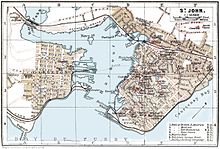
There are several marine facilities situated on either side of the harbour.
The west side of the harbour includes:
- the Lower West Terminal, for dry bulk and liquid bulk
- the American Iron and Metals Terminal, for dry bulk
- inter-provincial ferry terminal, operated by Bay Ferries for passenger and vehicle ferry service to Digby, Nova Scotia
- the Rodney Container Terminal, for container, dry bulk, break bulk and project cargo (operated by DP World formerly operated by Logistec Stevedoring, formerly operated by BrunTerm)
- the Navy Island Terminal, for container, dry bulk, break bulk and project cargo (formerly operated by ForTerm)
The east side of the harbour includes:
- HMCS Brunswicker, a Royal Canadian Navy reserve unit
- Canadian Coast Guard Station Saint John, a search and rescue station operating the lifeboat CCGS Courtney Bay
- the Long Wharf Terminal, for dry bulk, break bulk and project cargo
- the Pugsley Terminal, for dry bulk, break bulk and project cargo
- the Marco Polo Cruise Terminal[5][9]
- the Diamond Jubilee Cruise Terminal
- the Lower Cove Terminal, for dry bulk, break bulk and project cargo
- the Barrack Point Potash Terminal
- the Irving Oil Refinery Terminal, operated by Irving Oil
- the supertankers for Irving Oilat Mispec Point, located 9 kilometres southeast of the city
- the Canaport LNG liquified natural gas receiving terminal, located adjacent to the Canaport crude oil terminal[10]
Former facilities:
- the former Canadian Coast Guard Base Saint John property on the east side, undergoing redevelopment as Fundy Quay
- the former Saint John Shipbuilding property on the east side, currently vacant
- the former Lantic Sugar property on the east side, razed and currently vacant
- the former Intercolonial Railway grain elevator on the west side, razed and currently vacant
- the former Canadian Pacific Railway grain elevator on the west side, razed and currently vacant
See also
References
- UNECE. Retrieved September 9, 2020.
- ^ a b "Port of Saint John, Canada". www.findaport.com. Shipping Guides Ltd. Retrieved September 9, 2020.
- ^ a b https://www.sjport.com/wp-content/uploads/2022/05/Port-SJ-Annual-Report-2021-Eng-FINAL.pdf [bare URL PDF]
- ^ 2009 Annual Report, p.10 Archived 2010-12-24 at the Wayback Machine
- ^ a b Port of Saint John, Port Facilities Archived 2011-04-27 at the Wayback Machine
- ^ Port of Saint John, Port Conditions Archived 2010-12-24 at the Wayback Machine
- ^ David Hackett Fischer, Champlain's Dream, Knopf, 2008, p. 166
- ^ Dictionary of Canadian Biography, "Robert Foulis"
- ^ Marco Polo Cruise Terminal
- ^ Canaport LNG
Further reading
- Frederick William Wallace, The Romance of a Great Port: The Story of Saint John, New Brunswick (1935)

