
Prebends Bridge
Prebends Bridge | |
|---|---|
Grade I listed | |
| Preceded by | Kingsgate Bridge |
| Followed by | Framwellgate Bridge |
| Characteristics | |
| Design | Semi-circular arch bridge |
| Material | Stone |
| No. of spans | 3 |
| History | |
| Designer | George Nicholson |
| Construction start | 1772 |
| Construction end | 1778 |
| Location | |
 | |
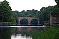
Prebends Bridge, along with Framwellgate and Elvet bridges, is one of three stone-arch bridges in the centre of Durham, England, that cross the River Wear.
History
Prebends Bridge was designed by George Nicholson[1] and built from 1772 to 1778. The bridge was built on the instructions of the Dean of Durham and served as a private road for the Dean and Chapter of Durham, giving access from the south through the Watergate.[2]
It replaced a temporary bridge built after the footbridge, built in 1574, was swept away during a flood in 1771.[3] The current bridge affords an excellent view of the cathedral and was built specifically with aesthetic considerations in mind - it was built slightly north of the prior bridge, at a wider part of the river, to improve the views available.[4] Trees were planted along the riverbank to complete the Romantic picture.[2]
Forming part of the estate of
In autumn 2010 the bridge was temporarily reopened to road traffic under 3 tonnes while Saddler Street was closed because of extensive repaving works as part of the Heart of the City project, sponsored by Durham City Vision.[5]
Plaque
Prebends Bridge has a plaque to display Sir Walter Scott's words about Durham:[6]
Grey towers of Durham
Yet well I love thy mixed and massive piles
Half church of God, half castle ‘gainst the Scot
And long to roam these venerable aisles
With records stored of deeds long since forgot
-
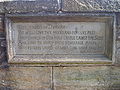 Inscription of Scott's words
 -
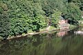 Durham School Boat Club's boat house as seen from the bridge
 -
 From downstream
 -
 View from the north, note thelay-by(originally used as a meeting place for wide vehicular traffic) on the left.
 -
 A pedestrian crosses Prebends Bridge in winter
.jpg)


References
- ^ Prebends Bridge at Structurae
- ^ a b Wright, Colin. "Durham, Prebends Bridge". www.bl.uk. Retrieved 25 December 2017.
- ^ "The city of Durham - Rivers, bridges and mills | A History of the County of Durham: Volume 3 (pp. 62-64)". British-history.ac.uk. 22 June 2003. Retrieved 26 February 2013.
- ^ "Historic Bridges - Durham World Heritage Site". www.durhamworldheritagesite.com. Retrieved 25 December 2017.
- ^ "Durhamcityvision.com". Durhamcityvision.com. Retrieved 26 February 2013.
- ^ "Three Rivers Cycleway - Bridges - River Wear". Cycle-routes.org. Retrieved 26 February 2013.
External links
54.771, -1.5793