
Prospect Hill, Waltham, Massachusetts
| Prospect Hill Park | |
|---|---|
 | |
 | |
| Location | Waltham, Massachusetts |
| Coordinates | 42°23′12″N 71°15′16″W / 42.3867°N 71.2544°W |
| Area | 273 acres (110 ha) |
| Elevation | 485 feet (148 m) (maximum) |
| Created | 1893 |
| Operated by | City of Waltham |
| Website | www |
Prospect Hill is a hill in
There are two different summits; Big Prospect, at 485 feet (148 m), and Little Prospect at 435 feet (133 m). Both summits provide some of the best views of the Boston basin. In clear weather, Monadnock, 54 miles away, is visible in an approximately northwest direction. The hill and the surrounding area make up the 273-acre (110 ha) Prospect Hill Park, a municipal park with numerous hiking trails and picnic areas that is the oldest and largest public open space in Waltham.[1]
History
Waltham acquired approximately 75 acres (30 ha) for the park from private landowners in 1893. This area comprised the two peaks and their immediate surroundings. Additional land was purchased over several decades and the park reached 219 acres (89 ha) in 1927.[2] It was improved with trails,[3] picnic areas, fences and other amenities and generally well maintained through the first half of the 20th century. Vegetation management included the clearing of dead trees and underbrush, as well as the planting of thousands of trees.[4] As a result of additional land purchases, the parked reached 250 acres by 1997.[2] Its current size is 273 acres.[5]
In 2021, the main park entrance from Totten Pond Road was temporarily closed as construction began on a capital improvement project to add "a water spray park, children’s playground area, picnic area, pavilion, multipurpose half court and a gaga pit".[6] Construction is expected to be complete in Fall 2021, when planning for a second phase of improvements will begin.
Ski slope
Additional land was added in 1948 for a ski slope. Slope construction was performed mostly by volunteers and included lights for night skiing. Natural snow cover was poor and there was little utilization due to insufficient snow for many years until snow making equipment was installed in 1968. A
Due to the topography of Big Prospect, a very unusual configuration existed, with the novice area above a much steeper expert slope.[7]
Nearby development

The construction of Route 128 less than 1,000 feet (300 m) west of the park led to the construction of several office buildings next to the park's western boundary.
The former headquarters of the
Water tanks

In 1974, the city of Waltham built two water tanks near the summit of Big Prospect to hold eight million gallons of water. Their elevation guarantees good water pressure throughout the city.
Other towers

In 1917, a
Projects included Experimental SAGE Subsector in the 1950s and the Joint Tactical Information Distribution System in the 1970s.
In 1997, the Air Force vacated Prospect Hill Park, and in 2002 all radio equipment was relocated to Big Prospect, serving Waltham's fire, police, public works, parks and recreation departments, the
Gallery
-
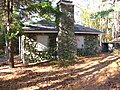 A park building in 2011
 -
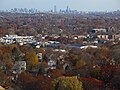 Boston seen from the park
 -
 View to northwest includesCambridge Reservoir
 -
 Picnic area
 -
 Glacial boulder


References
- ^ "Prospect Hill Park Trails" (PDF). www.walthamlandtrust.org. Retrieved 19 May 2021.
- ^ a b c "A Master Plan for the Restoration and Improvement of Prospect Hill Park, Waltham, Massachusetts, August 1997" (PDF). City of Waltham. Retrieved 20 May 2021.
- ^ "Prospect Hill Park". AllTrails. Retrieved 20 May 2021.
- ^ a b Lowe, Elizabeth M. (2003). "Prospect Hill Park: Its Creation, Decline, and Renewal" (PDF). Retrieved 21 September 2015.
- ^ "Prospect Hill Park". City of Waltham. Retrieved 20 May 2021.
- ^ "Capital Improvement Project". City of Waltham. Retrieved 20 May 2021.
- ^ "Prospect Hill".
- ^ "Former Polaroid site in Waltham starts new life in retail". Boston Globe. 18 January 2015. Retrieved 19 July 2021.
- ^ a b "1265 Main". Retrieved 19 July 2021.
- ^ "Peek inside the new Clark's HQ". Wicked Local Waltham. 31 October 2016. Retrieved 19 July 2021.