
Puʻuhonua o Hōnaunau National Historical Park
| Puʻuhonua o Hōnaunau National Historical Park | |
|---|---|
 Reconstructed Hale o Keawe | |
 | |
| Location | Hawaii County, Hawaii, United States |
| Nearest city | Holualoa, Hawaiʻi |
| Coordinates | 19°25′19″N 155°54′37″W / 19.42194°N 155.91028°W |
| Area | 420 acres (170 ha)[1] |
| Established | July 26, 1955 |
| Visitors | 421,027 (in 2016)[2] |
| Governing body | National Park Service |
| Website | Puʻuhonua o Hōnaunau National Historical Park |
Puʻuhonua o Hōnaunau National Historical Park is a United States
Puʻuhonua o Hōnaunau is one of the only four places in Hawaii where the flag of Hawaii can officially fly alone without the American flag; the other three places are ʻIolani Palace, the Mauna ʻAla and Thomas Square.[3][4]
Park name and features
The 420 acre (1.7 km2) site was originally established in 1955 as City of Refuge National Historical Park and was renamed on November 10, 1978. In 2000 the name was changed by the Hawaiian National Park Language Correction Act of 2000 observing the Hawaiian spelling.[5] It includes the puʻuhonua and a complex of archeological sites including: temple platforms, royal fishponds, sledding tracks, and some coastal village sites. The Hale o Keawe temple and several thatched structures have been reconstructed.
Hale o Keawe heiau

Hale o Keawe was an ancient Hawaiian
The heiau contained 23 remains including that of Keaweʻīkekahialiʻiokamoku. It was situated near a great ancient wall near the royal residence to the east side of the wall. Further south were further
It was believed that additional protection to the place of refuge was received from the
The heiau in the park was reconstructed in the 1960s.[14]
-
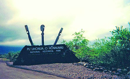 The entrance to the park.
 -
 Hawaiian hale (house) at the Puʻuhonua o Hōnaunau National Historical Park.
 -
 Protector kii (statues) at the Place of Refuge.


See also
References
- ^ "Geology of Puʻuhonua o Hōnaunau National Historical Park". www.usgs.gov. Retrieved September 13, 2022.
- ^ "National Park Service Visitor Use Statistics". National Park Service. Retrieved April 26, 2017.
- S2CID 214511964.
- ^ Fuller, Landry (August 2, 2016). "Flying high". West Hawaii Today. Kailua-Kona: Oahu Publications, Inc. Retrieved April 1, 2020.
- ^ "Hawaiian National Park Language Correction Act of 2000 (S.939)" (PDF). Govtrack.us. Retrieved July 28, 2017.[permanent dead link]
- ^ ISBN 978-0-8248-1938-5.
- ^ Pu'uhonua-o-Honaunau, City of Refuge National Historic Park, Natural and Cultural Resources Management Plan and Environmental Assessment (EA). 1976. pp. 25–26.
- ^ Ala Kahakai National Trail, Hawaii County: Environmental Impact Statement. 1998. p. 1.
- ISBN 978-0-8248-1739-8.
- ISBN 978-0-520-26725-1.
- ISBN 978-1-4396-1403-7.
- ^ Rowland Bloxam (1920). "Visit of H.M.S. Blonde to Hawaii in 1825". All About Hawaii: Thrum's Hawaiian Annual and Standard Guide. Thomas G. Thrum, Honolulu: 66–82.
- ^ Alexander, William DeWitt (1894). "The "Hale o Keawe" at Honaunau, Hawaii". Journal of the Polynesian Society. 3. London: E. A. Petherick: 159–161.
- ^ "Hale o Keawe - Puʻuhonua o Hōnaunau National Historical Park (U.S. National Park Service)". www.nps.gov. Retrieved November 6, 2021.
- Ward, Greg. 2004, The Rough Guide to Hawaii. Rough Guides.
External links
| External videos | |
|---|---|
 Puʻuhonua o Hōnaunau National Historical Park travel guide from Wikivoyage
- Pu`uhonua o Honaunau National Historical Park – National Park Service official site
- U.S. Geological Survey Geographic Names Information System: Puʻuhonua o Hōnaunau National Historical Park
- Photo essay on residences of Hawaiian Kings
- Go Hawaii article about the park with photos(archived)
- Photographs of the reflecting pools at Pu`uhonua o Honaunau National Historical Park *Broken Link*[permanent dead link]