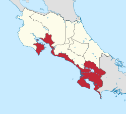
Puntarenas Province
Puntarenas | |
|---|---|
 | |
| Coordinates: 9°58′41″N 84°49′50″W / 9.97794°N 84.83068°W | |
| Country | |
| Capital city | Puntarenas (pop. 102,504) |
| Largest city | Puntarenas |
| Area | |
| • Total | 11,266 km2 (4,350 sq mi) |
| Population (2011) | |
| • Total | 410,929 |
| • Density | 36/km2 (94/sq mi) |
| ISO 3166 code | CR-P |
| HDI (2019) | 0.787[1] high · 6th of 7 |
Puntarenas (Spanish pronunciation: .
Overview
The capital is Puntarenas. The province covers an area of 11,266 square kilometres (4,350 sq mi), and has a population of 410,929.[2] It is subdivided into 11 cantons. For administrative purposes, the island Isla del Coco, 500 kilometres (310 mi) offshore in the Pacific Ocean, is considered a part of this province.
Canton (Capital):
- Buenos Aires)
- Corredores (Ciudad Neily at Corredor district)
- San Vito)
- Esparza (Esparza city at Espíritu Santo district)
- Garabito (Jacó)
- Golfito (Golfito)
- Montes de Oro (Miramar)
- Osa (Ciudad Cortés)
- Parrita (Parrita)
- Puntarenas (Puntarenas)
- Quepos (Quepos)
- Monteverde (Monteverde)
- Puerto Jiménez (Puerto Jiménez)
Notable places

References
- ^ "Sub-national HDI - Area Database - Global Data Lab". hdi.globaldatalab.org. Retrieved 2018-09-13.
- ^ Resultados Generales Censo 2011 Archived 2012-10-21 at the Wayback Machine p. 22
External links
Wikimedia Commons has media related to Puntarenas Province.


