
Pursley's Ferry Historic District
Pursley's Ferry Historic District | |
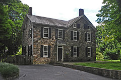
 Hart Johnson House | |
   | |
| Location | Old River Road at Church Road, Holland Township, New Jersey |
|---|---|
| Coordinates | 40°34′36″N 75°11′28″W / 40.57667°N 75.19111°W |
| Area | 61 acres (25 ha) |
| Architectural style | Federal |
| NRHP reference No. | 80002495[1] |
| NJRHP No. | 1598[2] |
| Significant dates | |
| Added to NRHP | October 8, 1980 |
| Designated NJRHP | July 12, 1978 |
Pursley's Ferry Historic District is a 61-acre (25 ha)
contributing buildings.[3]
History
Pursley's Ferry, also spelled Parsley, is located south of the mouth of the
Delaware Canal, Delaware and Raritan Canal and Belvidere Delaware Railroad during the early 19th century ended the need for the ferry.[3]
Description
The Hart Johnson House is a late 18th century two and one-half story brick farmhouse built with Federal style and featuring Flemish bond.[3]
Gallery
-
 Parsley Ferry on 1777 map by William Faden
 -
 Historic District information sign
 -
 Purcell/Brinks House at the ferry crossing


References
- ^ "National Register Information System – (#80002495)". National Register of Historic Places. National Park Service. November 2, 2013.
- ^ "New Jersey and National Registers of Historic Places – Hunterdon County" (PDF). New Jersey Department of Environmental Protection – Historic Preservation Office. March 23, 2021. p. 9.
- ^ a b c Karschner, Terry (January 1978). "National Register of Historic Places Inventory/Nomination: Pursley's Ferry Historic District". National Park Service. With accompanying 21 photos
External links
 Media related to Pursley's Ferry Historic District at Wikimedia Commons
| Topics |  | |
|---|---|---|
| Lists by county | ||
| Other lists | ||