
Rüppurr
Rüppurr | |
|---|---|
 Coat of arms | |
Location of Rüppurr in Karlsruhe Urban district | |
| City | Karlsruhe |
| Area | |
| • Total | 7.0268 km2 (2.7131 sq mi) |
| Elevation | 118 m (387 ft) |
| Population (2020-12-31)[1] | |
| • Total | 10,864 |
| • Density | 1,500/km2 (4,000/sq mi) |
| Time zone | UTC+01:00 (CET) |
| • Summer (DST) | UTC+02:00 (CEST) |
| Postal codes | 76199 |
| Dialling codes | 0721 |

Rüppurr is a district in the south of Karlsruhe, Baden-Württemberg, Germany, with around 11,000 inhabitants. The district borders on the neighboring town of Ettlingen and is considered to be one of the more affluent residential areas in Karlsruhe.[citation needed]
History
Rüppurr was first mentioned on February 9, 1103, in a document from the Hördt monastery under the name Rietburi.
Rüppurr is a Baden village founded on the gravel deposits of the Kinzig-Murg river. A
Rüppurr is the
In 1907, Rüppurr was incorporated into Karlsruhe. In the same year Hans Kampffmeyer, Friedrich Ostendorf, Friedrich Ettlinger, and others founded the Gartenstadt Karlsruhe cooperative. From 1911 the first houses were built near today's Ostendorfplatz; architects like Max Laeuger worked on the planning.
From 1931, the Protestant Diakonissenanstalt established the Diakonissenkrankenhaus Rüppurr, today a central care hospital with 464 beds, 60 places for geriatric rehabilitation and 1350 employees.
The
In the
Name
The name "Rüppurr" comes from Riet-Burg = Burg im Sumpf, Das Haus im Ried (Castle in the swamp, The house in the reed/moor). Among the residents of Rüppurr, the alternative place name "Rieberg" is sometimes still in use, for example in the name of the district gazette "Rieberger Bläddle".[5]
Traffic

Road traffic
Despite the quiet residential area, Rüppurr has very good transport links. The main street is Herrenalber Straße, running in north-south direction, which separates the town into the older western and newer eastern parts and connects the Karlsruhe city center with Ettlingen. At its southern end, on the border with Ettlingen, there is the motorway junction "Ettlingen - Bad Herrenalb - Karlsruhe Rüppurr" of the Bundesautobahn 5. At its northern end, Herrenalber Strasse connects to the southern bypass, which is Karlsruhe's main traffic artery in an east-west direction represents.
Rail traffic
From 1844 until the relocation of the Karlsruhe main train station in 1913, there was a train station on the
Tourist attractions
On the roof of the Max-Planck-Gymnasium is the Volkssternwarte Karlsruhe, built in 1957, which houses a historical telescope from 1859. The public observatory regularly offers public observations of the sky and astronomical lectures. However, only the Rote Haus, which was recently renovated, and the old watermill on the Alb are all that remain of the Rüppurrer Schloss. The rest of the former castle area is used as a parking lot for e.g. the Mostfest (Oktoberfest) used.
The Protestant Auferstehungskirche (Church of the Resurrection), built in 1907 in the neo-baroque style, is located in the center of Rüppurr. In the adjoining area is the Rüppurr cemetery, which is laid out as a park cemetery.
-
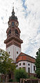 Protestant Auferstehungskirche
 -
 Catholic Christkönigkirche


Notable people
- Wolf Wondratschek (* 1943), grew up in Rüppurr[6]
References
- ^ "Die Karlsruher Bevölkerung im IV. Quartal 2020" (PDF). Stadt Karlsruhe. Retrieved 24 September 2021.
- ISBN 978-1147484014.
- ^ Remling, Franz Xaver (1836). Urkundliche Geschichte der ehemaligen Abteien und Klöster im jetzigen Rheinbayern [Documented history of the former abbeys and monasteries in what is now Rhine Bavaria]. Vol. 2. Christmann. p. 21.
- ^ "Grabplatten" (PDF). st-nikolaus-ka.de. Archived from the original (PDF) on 2018-07-08. Retrieved 2021-05-13.
- ^ "Karlsruhe: Rüppurr". www.karlsruhe.de (in German). Retrieved 2021-05-13.
- ISSN 0931-9085. Retrieved 2021-05-13.
External links
- 900 years of Rüppurr - a tour of the local history - karlsruhe.de (German)
- www.rueppurr.de (Official website of the Bürgergemeinschaft Rüppurr e.V. (German))
| International | |
|---|---|
| National | |