
Reddersburg
Reddersburg | ||
|---|---|---|
PO box 9904 | ||
| Area code | 051 | |
Reddersburg is a small sheep and cattle farming town in the
.History
The town was established around the Reformed Church Reddersburg, which was established on the farm Thorbeck on 7 May 1859. The church counsel bought the farm Vlakfontein to establish the town. The name is Afrikaans and means "Saviour's Town", from "God is our Saviour". The town was managed by the church until 1894 when it was handed over to the municipality on agreement that a hereditary tenure of 33 pounds sterling must be paid by the municipality to the church on an annual basis.
During the
Royal Irish Rifles on April 4, 1900, and obtained their surrender the next day.[4]
The Sarie Marais Hotel is one of the landmarks in the town.
-
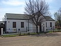 Old CNO school
 -
 21 Boshof street


References
- hdl:2263/26503.
- ^ Free State Tourism.org
- ^ a b c d Main Place Reddersburg from Census 2011.
- ^ Thomas Pankenham, The Boer War (Random House, 1979) p417
Places adjacent to Reddersburg | ||||||||||||||||
|---|---|---|---|---|---|---|---|---|---|---|---|---|---|---|---|---|
| ||||||||||||||||
Municipalities and communities of Xhariep District Municipality, Free State | ||
|---|---|---|
District seat: Trompsburg | ||
| Kopanong | .svg) | |
| Letsemeng | ||
| Mohokare | ||
This Free State location article is a stub. You can help Wikipedia by expanding it. |