
Reform Tower, Peterhead
| Reform Tower | |
|---|---|
.jpg) The building in 2020, looking southeast | |
 | |
| General information | |
| Type | Tower |
| Location | Meethill, Peterhead, Aberdeenshire, Scotland |
| Coordinates | 57°29′31″N 1°47′56″W / 57.492014°N 1.798886°W |
| Completed | 1832 |
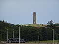
Reform Tower is an historic structure in Meethill, an area to the southwest of the Scottish town of
Category B listed building. In five stages, each narrowing slightly, the tower is constructed of squared granite. It was originally designed to be an observatory, but was not completed.[1]
The tower's
foundation stone was laid by George Mudie in August 1832. Its architect is not known.[1]
Gallery
-
 The tower viewed from west, beyond the A90
.jpg)
References
Sources
- Neish, Old Peterhead, p. 197
This article about a Scottish building or structure is a stub. You can help Wikipedia by expanding it. |