
River Skirfare
| River Skirfare | |
|---|---|
 River Skirfare | |
| Location | |
| Country | England |
| Physical characteristics | |
| Source | |
| • location | Confluence of Foxup Beck and Cosh Beck |
| • coordinates | 54°11′11″N 2°11′49″W / 54.186503°N 2.197014°W |
| • elevation | 1,470 ft (450 m) |
| Mouth | |
• location | River Wharfe |
• coordinates | 54°07′09″N 2°02′10″W / 54.119264°N 2.035975°W |
• elevation | 636 ft (194 m) |
| Length | 9.47 miles (15.24 km) |
| Basin features | |
| EA waterbody IDs | GB104027069250 GB104027069230 GB104027064180 |
River Skirfare | |||||||||||||||||||||||||||||||||||||||||||||||||||||||||||||||||||||||||||||||||||||||||||||||||||||||||||||||||||||||||||||||||||||||||||||||||||||||||||||||||
|---|---|---|---|---|---|---|---|---|---|---|---|---|---|---|---|---|---|---|---|---|---|---|---|---|---|---|---|---|---|---|---|---|---|---|---|---|---|---|---|---|---|---|---|---|---|---|---|---|---|---|---|---|---|---|---|---|---|---|---|---|---|---|---|---|---|---|---|---|---|---|---|---|---|---|---|---|---|---|---|---|---|---|---|---|---|---|---|---|---|---|---|---|---|---|---|---|---|---|---|---|---|---|---|---|---|---|---|---|---|---|---|---|---|---|---|---|---|---|---|---|---|---|---|---|---|---|---|---|---|---|---|---|---|---|---|---|---|---|---|---|---|---|---|---|---|---|---|---|---|---|---|---|---|---|---|---|---|---|---|---|---|
| |||||||||||||||||||||||||||||||||||||||||||||||||||||||||||||||||||||||||||||||||||||||||||||||||||||||||||||||||||||||||||||||||||||||||||||||||||||||||||||||||
River Skirfare is a small river in North Yorkshire, England, that flows through Littondale and ends where it joins the larger River Wharfe. The source is the confluence of Foxup Beck and Cosh Beck at the hamlet of Foxup.
The name is of Old Norse origin, from skírr "bright" or "clear" and far "river-course".[1]
Course
The source of the river is the confluence of Foxup Beck and Cosh Beck at the hamlet of Foxup, some 1,470 feet (450 m) above sea level.[2][3] To the east bank lays Hawkswick Moor and on the west bank lays Darnbrook Fell, Hawkswick Clowder and Pen-y-ghent Fell. The river meanders consistently south-east for approximately 9.5 miles (15.3 km) to the confluence with the River Wharfe.[4]
The river drains a catchment area of 20.27 square miles (52.51 km2).[5][6][7] The upper reach of the river above the hamlet of Litton is known to dry up in the summer months with the water flowing underground.[8] It is known that there are huge caverns underneath Littondale where the water sinks, but it reappears south of Arncliffe.[9] Outside of summer, the normal range of the water can be up to 1 foot 11 inches (0.58 m), however, the highest level recorded is of 9 feet 2 inches (2.79 m), at Skirfare Bridge on 20 February 2022.[10] The water seeping underground is what Marie Hartley and Joan Ingilby state is the reason that saved the valley of Littondale from becoming a huge reservoir.[11] Leeds council considered taking the waters from the river in the 1850s, which they labelled as the "Skirfare Scheme."[12]
Flora and fauna
Trout and bullhead are known to be in the river and its tributaries. Trout use many of the smaller side streams as nurseries for their fry.
Literary connections
The valley of Littondale was also previously known as Amerdale, and in his poem The White Doe of Rylstone, Wordsworth refers to the "..deep fork at Amerdale..". In the Water-Babies by Charles Kingsley, Littondale and the Skirfare are referred to as Vendale.[17]
Lists
Tributaries
From the source of the river:
- Halton Gill Beck
- Newshot Gill
- Hesleden Beck[18]
- Potts Beck
- Fosse Beck
- Cowside Beck[19]
- Cote Gill[20]
- Sleets Gill Beck[20]
- Moss Beck
Settlements
From the source of the river:
(valley called Littondale)[21]
Crossings

From the source of the river:
- Foxup Bridge
- Halton Gill Bridge
- Unnamed bridge to Nether Hesleden[11]
- Fording point
- New Bridge on farm track[27]
- Footbridge near Litton
- Fording point south of Litton
- Arncliffe Bridge[28]
- Footbridge north of Hawkswick
- Hawkswick Bridge[29]
- Skirfare Bridge on B6160[30]
Gallery
-
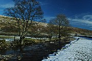 River Skirfare passing through Halton Gill
 -
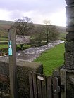 Litton walking sign on Halton Gill Bridge
 -
 Ford, River Skirfare near Litton
 -
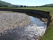 River erosion near Arncliffe, Littondale, Yorkshire Dales
 -
 Footbridge on Old Gang Lane, Hawkswick
 -
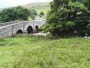 Skirfare Bridge near confluence with River Wharfe


References
- ^ Smith, A. H. (1962). The Place-names of the West Riding of Yorkshire. Vol. 7. Cambridge University Press. p. 138.
- ^ Grey 2020, p. 2.
- ISBN 0903116049.
- ^ Chrystal 2017, p. 101.
- ^ "Skirfare from Source to Heselden Beck | Catchment Data Explorer | Catchment Data Explorer". environment.data.gov.uk. Retrieved 26 December 2023.
- ^ "Skirfare from Heselden Beck to Cowside Beck | Catchment Data Explorer | Catchment Data Explorer". environment.data.gov.uk. Retrieved 26 December 2023.
- ^ "Skirfare from Cowside Beck to River Wharfe | Catchment Data Explorer | Catchment Data Explorer". environment.data.gov.uk. Retrieved 26 December 2023.
- ^ "Littondale : Yorkshire Dales National Park". yorkshiredales.org.uk. Retrieved 26 December 2023.
- ^ Pritchard, Jonathan (16 June 2023). "Pictures show how river in Yorkshire has dried up as warm weather continues into the weekend". The Yorkshire Post. Retrieved 26 December 2023.
- ^ "River Skirfare level at Skirfare Bridge - GOV.UK". check-for-flooding.service.gov.uk. Retrieved 26 December 2023.
- ^ a b Hartley & Ingilby 1991, p. 51.
- OCLC 17722490.
- ^ Grey 2020, p. 6.
- ISBN 9780007503698.
- ^ "Other Orchids of the Dales : Yorkshire Dales National Park". www.yorkshiredales.org.uk. Retrieved 28 December 2023.
- ISSN 0140-0460.
- ISSN 0962-1644.
- ^ Hartley & Ingilby 1991, p. 47.
- ISBN 9780007503698.
- ^ ISBN 9781851532186.
- ^ Chrystal 2017, p. 103.
- ^ Chrystal 2017, p. 35.
- ^ Chrystal 2017, p. 40.
- ^ Chrystal 2017, p. 55.
- ^ Chrystal 2017, p. 13.
- ^ Chrystal 2017, p. 42.
- ^ Historic England. "New Bridge (Grade II) (1132159)". National Heritage List for England. Retrieved 26 December 2023.
- ^ Historic England. "Arncliffe Bridge over River Skirfare (Grade II) (1316768)". National Heritage List for England. Retrieved 26 December 2023.
- ^ Historic England. "Hawkswick Bridge (Grade II) (1173548)". National Heritage List for England. Retrieved 26 December 2023.
- ^ Historic England. "Skirfare Bridge (Grade II) (1296279)". National Heritage List for England. Retrieved 26 December 2023.
Sources
- Chrystal, Paul (2017). The Place Names of Yorkshire; Cities, Towns, Villages, Rivers and Dales, some Pubs too, in Praise of Yorkshire Ales (1 ed.). Catrine: Stenlake. ISBN 9781840337532.
- Grey, Jonathan (2020). Project Proposal Amerdale Estate, River Skirfare & Cosh Beck September 2020 (PDF). wildtrout.org (Report). Retrieved 26 December 2023.
- Hartley, Marie; Ingilby, Joan (1991) [1956]. The Yorkshire Dales. Otley: Smith Settle. ISBN 1-870071-72-7.