
Saarschleife


The Saarschleife, also known as the Great Bend in the Saar at Mettlach, is a water gap carved by the Saar River through a quartzite layer and today one of the most well-known tourist attractions of the Saarland.
Location
The Saarschleife begins near the Besseringen section of the town of Merzig and ends in Mettlach. Although Besseringen and Mettlach are only separated by approximately two kilometers, the Saar makes a winding path that lasts nearly ten kilometers.
On the forested mountains within the Saarschleife, there are the historical sites of the former cloister church of St. Gangolf in addition to remnants of the former cloister complex as well as the ruins of Montclair fortress. The only locale located immediately on the Saarschleife is the village of Dreisbach, which can be reached by ferry.
On both the inner and outer riverbends run hiking and biking paths. An area west of the Saarschleife known as the "Steinbachtal" of approximately 100 hectares has been designated as a protected area.
Geography
The narrowing of the Saarschleife between Besseringen and Dreisbach stems from the fact that the Saar, coming from the
This mountain spur around which the Saar flows has a length of 4 km and reaches its highest point at 318 m above sea level, while the surface of the Saar is around 166 m above sea level. The entire area around the Saarschleife is largely covered by a forest that is largely untouched. A beech forest grows on the remnants of the colored sandstone while hornbeam and oaks predominate on quartzite. On the steep slopes, the forests transition into a bush forest of hornbeam and oak. Due to the favorable climate, the evergreen sub-Mediterranean Atlantic holly grows here. Only lichens and mosses settle on the so-called "Rosseln" the scree heaps created by weathering.
History

The advantage offered by a
Nearly two centuries later in 1180, Arnold I., another Archbishop of Trier, authorized the construction of a new castle on the grounds. Given the name Montclair (
During the
Treetop walk and observation tower
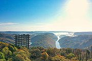
On July 23, 2016, the Treetop Walk Saarschleife opened to the public with an observation tower soaring above the historically popular vantage point known as "the Cloef."[5] From the observation tower, visitors can see much further than from the Cloef including the Mettlach parish church as well as the power plant at Ensdorf.
Famous visits
The Saarschleife is considered the symbol of the
-
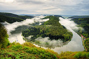 View of the Saarschleife from the Cloef
 -
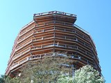 Observation tower of the Treetop Walk Saarschleife
 -
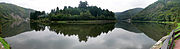 Saarschleife panorama from the banks of the Saar
 -
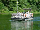 The ferry ship Welles transports passengers across the Saar near the Saarschleife.
 -
 Observation tower on the Treetop Walk Saarschleife
 -
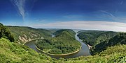 Panoramic View of Saarschleife seen from Cloef


49°30′04″N 6°32′58″E / 49.50111°N 6.54944°E
References
- ^ Herbert Liedtke, Karl-Heinz-Hepp, Christoph Jentsch: Das Saarland in Karte und Luftbild, Ein Beitrag zur Landeskunde, hrsg. vom Landesvermessungsamt des Saarlandes, Neumünster 1974, S. 80–81.
- ^ Herbert Liedtke, Karl-Heinz-Hepp, Christoph Jentsch: Das Saarland in Karte und Luftbild, Ein Beitrag zur Landeskunde, hrsg. vom Landesvermessungsamt des Saarlandes, Neumünster 1974, S. 80–81.
- ^ Gisela Tascher: Das erste Geschenk des Führers - Noch vor dem Gautheater in Saarbrücken planten die Nazis eine Ordensburg an der Saarschleife, in: Saargeschichten Ausgabe 1, 2012, S. 4–9.
- ^ Dietmar Klostermann: Hitlers irrer Saarschleifen-Plan, Saarbrücker Zeitung, 14. März 2012.
- ^ "Baumwipfelpfad Saarschleife". Retrieved 2016-09-27. Operator's Homepage
External links
- Literature about the Saarschleife in the Saarländischen Bibliographie
- Saarschleife und Umgebung. Gallery by Wolfgang Reichel, Merzig-Besseringen.
- Panoramabild Saarschleife 360° Panoramic Images of the Saarschleife
| International | |
|---|---|
| National | |