
Salavan province
Salavan province
ແຂວງ ສາລະວັນ | |
|---|---|
UTC+07 | |
| ISO 3166 code | LA-SL |
| HDI (2017) | 0.498[1] low · 16th |
Salavan (also Saravane,
Salavan province covers an area of 16,389 square kilometres (6,328 sq mi). The province borders
History
Approximately 1,500 years ago,
In the Indochina war, Salavan town was subject to extensive depredation when its control frequently shifted between the Royal Forces and the Pathet Lao. It was subsequently rebuilt with brick masonry and timber buildings, coexisting with the few old buildings which survived the war.[2]
Geography
Salavan province covers an area of 16,389 square kilometres (6,328 sq mi).
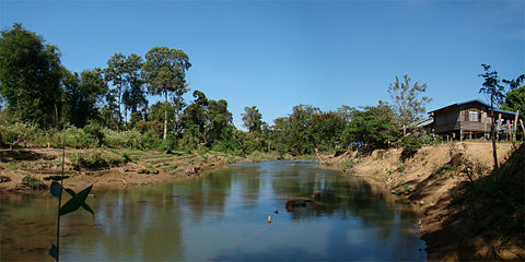
The Saravan city is capital of the province is located on a bend of
Nang Bua Lake, from where the Se Bon River originates, is 15 kilometres (9.3 mi) from the city. The lake has a few Siamese crocodiles (Khai in Lao). Nearby is a hill, Phu Katae at 1,588 metres (5,210 ft) where the CIA airstrip was once functional.[2]
Its origin is volcanic with mountains and wide valleys. The central part of the province is located on the
Access to the province is difficult as the road network is not in good condition, particularly during the monsoon rains.[7]
Protected areas
The Xe Sap
The "Mekong Channel from Phou Xiang Thong to Siphandon" IBA is 34,200 ha in size. There is a 10,000 ha overlap with the
The Phou Xiang Thong IBA (36,650 hectare) is situated within the Phou Xiengthong NBCA (120,000 hectare). The IBA encompasses two provinces, Salavan and Champasak. The IBA is located at an altitude of 40–500 metres (130–1,640 ft) above sea level. Its topography is characterized by low hills, lowlands, rivers, and seasonal streams. Its habitat contains dry deciduous tropical forest, moist deciduous tropical forest, semi-evergreen tropical rain forest, mixed deciduous forest, dry
Xe Bang Nouan (XBN) Protected Area was established on 29 October 1993 covering an area of 1260 km2, and extending over Salavan and Savannakhet provinces. The topography of the reserve lies in the elevation range of 200-1000m; has flat to gently rolling terrain below 400 m elevation in the north and south of the
Administrative divisions
The province is made up of the following eight districts:[4]
| Map | Code | Name | Lao script |
|---|---|---|---|

| |||
| 14-01 | Salavan District
|
ເມືອງສາລາວັນ | |
| 14-02 | Ta Oy District
|
ຕາໂອ້ຍ | |
| 14-03 | Toumlane District
|
ຕຸ້ມລານ | |
| 14-04 | Lakhonepheng District
|
ລະຄອນເພັງ | |
| 14-05 | Vapy District
|
ວາປີ | |
| 14-06 | Khongsedone District
|
ຄົງເຊໂດນ | |
| 14-07 | Lao Ngarm District
|
ເລົ່າງາມ | |
| 14-08 | Sa Mouay District
|
ສະມ້ວຍ |
Demographics
The population of the province as per the 2015 census was 396,942 distributed over eight districts.[12] The ethnic groups in the province comprise the Tahoy, Pako, Katang, Kado, Suay, and Laven.[7]
-
 Ban Huay Lanong, a Tahoy village
 -
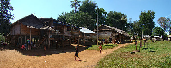 Ban Khiang Tadsoung, an Alak village


Economy
Salavan province is one of the most important coffee producing areas of Laos along with Champasak province and Sekong province.[13] Arabica coffee and coffee beans are the products of the Bolaven Plateau which is an export revenue product and can also be bought in villages along the roads.[7]
Landmarks
Tahoy town is where the Tahoy ethnic groups reside; there are about 30,000 of them. Their cultural practice involves shamanistic rituals combined with animism. During the festivals, people of the town erect totems made in the form of a diamond as a warning to outsiders not to enter the town. Tigers are a common sight in this town which keeps the people indoors during the night.[2]
Tatlo on the Bolaven Plain is known for Katu and Alak villages, as well as a waterfall.[14]
-
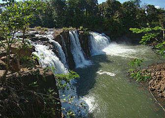 Tatlo Waterfalls
 -
 Downstream of Tatlo Waterfalls
 -
 Elephant bath in the Tatlo River


Culture
References
- ^ "Sub-national HDI - Area Database - Global Data Lab". hdi.globaldatalab.org. Retrieved 2018-09-13.
- ^ ISBN 9781741045680.
- ^ a b THE MINISTRY OF LABOUR AND SOCIAL WELFARE. "'CHASING HORIZONS': A STUDY INTO CROSS BORDER MIGRATION AND TRAFFICKING1 IN SEVEN VILLAGES OF LAKHONEPHENG DISTRICT SALAVAN PROVINCE, LAO PDR". Village Focus International. p. 5. Retrieved 6 December 2012.
- ^ a b c d "Saravane Province". Lao Tourism Organization. Retrieved 1 December 2012.
- ^ "Base Map:Lao People's Democratic Republic (LPDR)". UNOSAT. Retrieved 4 December 2012.
- ^ The Lao National Tourism Administration. "Salavan Province". Ecotourism Laos. GMS Sustainable Tourism Development Project in Lao PDR. Retrieved 1 December 2012.
- ^ a b c d "Salavan Province". Official web site of Laos Ecotourism Organization. Retrieved 10 December 2012.
- ^ "Important Bird Areas factsheet: Xe Sap". BirdLife International. 2012. Retrieved 6 December 2012.
- ^ "Important Bird Areas factsheet: Mekong Channel from Phou Xiang Thong to Siphandon". BirdLife International. 2012. Retrieved 6 December 2012.
- ^ "Important Bird Areas factsheet: Phou Xiang Thong". BirdLife International. 2012. Retrieved 6 December 2012.
- ^ "Xe Bang Nouan". Official web site of Laos Ecotourism Organization. Retrieved 10 December 2012.
- ^ "Results of Population and Housing Census 2015" (PDF). Lao Statistics Bureau. Retrieved 1 May 2020.
- ISBN 978-1-4527-9182-1. Retrieved 6 December 2012.
- ^ Bush, Elliot & Ray 2010, p. 298.
- ^ Miller & Williams 2008, p. 189.
Bibliography
- Bush, Austin; Elliot, Mark; Ray, Nick (1 December 2010). Laos 7. Lonely Planet. pp. 298–. ISBN 978-1-74179-153-2.
- Miller, Terry E.; Williams, Sean (2008). Southeast Asian Music. Psychology Press. pp. 189–. ISBN 978-0-415-96075-5.
Places adjacent to Salavan province | ||||||||||||||||
|---|---|---|---|---|---|---|---|---|---|---|---|---|---|---|---|---|
| ||||||||||||||||
| Prefecture | ||
|---|---|---|
| Province | ||
| Authority control databases: National |
|---|