
Salisbury, South Australia
| Salisbury Federal division(s) | Spence | ||||||||||||||
|---|---|---|---|---|---|---|---|---|---|---|---|---|---|---|---|
| |||||||||||||||
Salisbury (
History
Salisbury was founded when
Salisbury's first police station was established in 1859. [10]
The area's first school, Salisbury Public School, was completed in 1877.[11]
The town population numbered between 400 and 500 in 1881.[4]
The
In 1940 an
Two South Australian Australian Labor Party leaders, Lynn Arnold (Premier 1992–1993) and Mike Rann (Premier 2002–2011) both represented the Salisbury area in the South Australian Parliament. Arnold was elected as the MP for Ramsay, and then Taylor, and Rann was elected as the MP for Briggs and Ramsay.[citation needed]
Churches
The first St John's Anglican Church was established on the block in Church Street around 1846 or 1850, one of the first churches to be constructed in Salisbury. As the size of the congregation increased, a second church, designed by
In 1851, the first Methodist Church was erected. St. Augustine's Catholic Church was completed in March 1857.[19]
Demographics
52.1% were born in Australia, other countries of birth were England 4.2%, Bhutan 4%, Myanmar 3.8%, Afghanistan 3.7% and Nepal 3.3%. 52.2% spoke English only used at home. Other languages spoken at home are Nepali 8.0%, Hazaraghi 3.6%, Italian 3%, Vietnamese 2.2% and Arabic 1.9%.[when?]
Transport
Trains to and from Adelaide and Gawler from
Local buses from Salisbury Interchange, scheduled to connect with trains to and from Adelaide, use the Adelaide Metro integrated ticketing system. In May 2012 there are 13 local bus routes providing links to many of the northern suburbs, such as routes 400 and 430 to Elizabeth, route 415V to Golden Grove, routes 224, 225, 411 to Mawson Lakes, routes 225, 500, 502, 560 to Para Hills, routes 401, 411 to Paralowie and routes 404, 405 to Parafield Gardens.
Retail
The major retail zone in Salisbury is the Parabanks Shopping Centre, which is a short distance from Salisbury Interchange, and was first opened around 1977. The single-floor complex includes 74 stores and 3 anchor stores,[20] with a total floor area of 23,800 m2, and around 1,400 parking spaces. In April 2008, property group Stockland sold the shopping centre to the Angaet Group. In 2015, an $18 million redevelopment of the centre was approved by the Salisbury Council's Development Assessment Panel.[21] The redevelopment consisted of three stages, with five specialty stores added to the eastern side mall, the relocation of the Coles supermarket into the site of the former Harris Scarfe store, and external upgrades which were completed in October 2017.[22]
Gallery
-
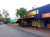
 City Centre, 2007
 -
 Salisbury Interchange
 -
 Parabanks Shopping Centre
 -
 John Street
 -
 Cemetery


See also
Notes
References
- ^ Australian Bureau of Statistics (28 June 2022). "Salisbury (SA) (suburb and locality)". Australian Census 2021 QuickStats. Retrieved 28 June 2022.
- ^ "The Late Mr. John Harvey". South Australian Register. 24 June 1899. p. 9. Retrieved 14 January 2024 – via Trove.
- ^ "A grand old pioneer". South Australian Register. Vol. LXI, no. 15, 402. South Australia. 25 March 1896. p. 6. Retrieved 21 May 2023 – via National Library of Australia.
- ^ a b c "Our History". City of Salisbury. Retrieved 7 March 2014.
- ^ Google (13 January 2024). "Wiltshire Street Street" (Map). Google Maps. Google. Retrieved 13 January 2024.
- ^ A City of Salisbury Publication, ed. (1985). Settlers on the Hill, A Local History of Para Hills. City of Salisbury, South Australia. p. 6.
- ^ Premier Postal History. "Post Office List". Premier Postal Auctions. Retrieved 26 May 2011.
- Among Ourselvesissue 235 November 1985 page 4
- The RecorderFebruary 1986 page 71
- ^ Lewis, H. John (1980). Salisbury South Australia: A History of Town and District. South Australia: Investigator Press Pty. Ltd. p. 121.
- ^ "Public School".
- ^ Marsden, Susan (2012). "A History of South Australian Councils to 1936" (PDF). Local Government Association of South Australia. p. 41. Retrieved 30 October 2015.
- South Australian Weekly Chronicle. Vol. XXVIII, no. 1, 405. South Australia. 25 July 1885. p. 7. Retrieved 4 September 2019 – via National Library of Australia.
- ^ Andrews, F. Brian (2006). "The Salisbury Munitions Tramways". Salisbury & District Historical Society. Archived from the original on 31 August 2006. Retrieved 15 July 2006.
- ^ "St John's Anglican Church". Discover Salisbury. 19 July 2023. Retrieved 14 April 2024.
- ^ "Ecclesiastical". Peter Moeck Architect. 19 October 2017. Retrieved 14 April 2024.
- ^ "Welcome to The Church of Saint John The Evangelist". Welcome to The Church of Saint John The Evangelist. 12 March 2024. Retrieved 14 April 2024.
- Facebook
- ^ Lewis, H. John (1980). Salisbury South Australia: A History of Town and District. South Australia: Investigator Press Pty. Ltd. pp. 67–81.
- ^ "Centre Directory". Parabanks Shopping Centre South Australia. Retrieved 18 October 2017.
- ^ "$18 million upgrade approved for Parabanks shopping centre in Salisbury". The Advertiser. Adelaide. 7 May 2015. Retrieved 5 November 2015.
- ^ "Centre Redevelopment". Parabanks Shopping Centre South Australia. Retrieved 18 October 2017.