Salobreña
Salobreña | ||
|---|---|---|
 Salobreña | ||
|
Postal code 18680 (Salobreña y La Caleta-Guardia), 18610 (Lobres) | ||
| Official language(s) | Spanish | |
| Website | www | |
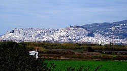
Salobreña (pronounced [saloˈβɾeɲa]) [2] is a town on the Costa Granadina in Granada, Spain. It claims a history stretching back 6,000 years.
There are two main parts of Salobreña; The first is The Old Town which sits atop a rocky prominence and is a cluster of whitewashed houses and steep narrow streets leading up to a tenth-century
The second part of Salobreña is new developments which spread from the bottom of the Old Town right to the beach. The whole town is almost surrounded by sugarcane fields on each side along the coast and further inland.
Another tourist attraction in Salobreña is 'El Peñón' (The Rock), which divides two of Salobreña's five beaches and juts out between Playa La Guardia and Playa de la Charca/Solamar and into the sea.
History
Geological background
At the close of the
Ancient
Archaeological finds show human habitation around Salobreña at the rocky promontory known as the Peñon beginning in the
Salobreña is thought to have experienced contact with the
Medieval
In 713 CE, the region of Elvira (roughly corresponding to the
In 1489, Granada came under Castilian rule, and
Modern
Sugar-cane remained key to the town's economy through the sixteenth century, returning to prominence in the nineteenth. In between, cotton became the dominant crop. The early-modern history of Salobreña is not well understood. In the nineteenth century, however, Salobreña was strategically important in the
Today, the economy of the coastal plain around Salobreña is based on tourism and sugarcane agriculture, while the mountains are characterised by terraced agriculture with almond and, increasingly, sub-tropical fruit trees (with
Climate

Salobreña's climate is a Mediterranean, semi-arid climate, with annual rainfall of 500mm per year, and whose microclimate is sub-tropical. In the hotter months, average temperatures are around 26 °C, peaking in August around the mid 30 °C's during the day and mid 20 °C's at night and around 13 °C in the colder months. The annual average temperature is 19 °C.[16]
See also
References
- ^ Municipal Register of Spain 2018. National Statistics Institute.
- ^ "Toponimia de la provincia y el Valle de Lecrín".
- ISBN 8487811132, pp. 7-8, 16.
- ISBN 8487811132, p. 23.
- ISBN 8487811132, pp. 7-8.
- ISBN 8487811132, pp. 8-9.
- ISBN 8487811132, pp. 9-10.
- ^ Carmen Trillo San José and Gari Amtmann, 'Un castillo junto al río Laroles: ¿Šant Afliy?', AyTM, 8 (2001), 305-23 (p. 309).
- ISBN 8487811132, p. 10.
- ^ José Navas Rodríguez and José María García-Consuegra Flores, 'La Salobreña islámica: Configuración de una madina Nazarí'[dead link] (2013).
- ISBN 8487811132, p. 10.
- ISBN 8487811132, pp. 10-11.
- ISBN 8487811132, pp. 11-15.
- ISBN 8487811132, pp. 17-19, 28.
- ^ "Adiós a la última planta azucarera de Europa". 21 April 2006.
- ISBN 8487811132, p. 17.
