
Sanjō Keihan Station
T11 Sanjō Keihan Station 三条京阪駅 | |||||||||||
|---|---|---|---|---|---|---|---|---|---|---|---|
| Coordinates | 35°0′33.4″N 135°46′25.58″E / 35.009278°N 135.7737722°E | ||||||||||
| Operated by | |||||||||||
| Line(s) | |||||||||||
| Platforms | 1 island platform | ||||||||||
| Tracks | 2 | ||||||||||
| Connections |
| ||||||||||
| Other information | |||||||||||
| Station code | T11 | ||||||||||
| History | |||||||||||
| Opened | 12 October 1997 | ||||||||||
| Passengers | |||||||||||
| FY2016 | 25,875 daily[1] | ||||||||||
| Services | |||||||||||
| |||||||||||
Sanjō Keihan Station (三条京阪駅 Sanjō Keihan Eki) is a subway station in Higashiyama ward, city of Kyoto, Kyoto Prefecture, Japan.
General information
Sanjō Keihan Station intersects with the
Kawaramachi shopping district. It is also the main station in Kyoto for trains to Yodoyabashi Station in Osaka
.
Connecting line
- Keihan Railway
- Sanjo Station)
Layout
Sanjō Keihan Station has an island platform with two tracks underground.
| 1 | ■ Tōzai Line | for Kyoto Shiyakusho-mae, Karasuma Oike and Uzumasa Tenjingawa |
| 2 | ■ Tōzai Line | for Hamaōtsu
|
-
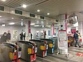 Ticket gates
 -
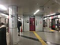 Platform


References
- ^ "京都市交通事業白書" (in Japanese). Kyoto Municipal Transportation Bureau.
External links
Stations of the Kyoto Municipal Subway Tōzai Line | ||
|---|---|---|