
Sea mark


A sea mark, also seamark and to navigate safely.
There are three types of sea mark: beacons fixed to the seabed or on shore, towers (sometimes rock cairns) built on the shore or on a submerged rock/object (especially in calmer waters), and buoys (consisting of a floating object that is usually anchored to a specific location on the bottom of the sea or to a submerged object).
Sea marks are used to indicate channels, dangerous rocks or
Marks are shown on nautical charts, using symbols that indicate their colour, shape and light characteristic, and are usually identified by name or number.
In a wider sense the phrase "sea mark" is often understood to include all types of landmarks, structures and devices that can be used to provide warning and guiding signs to mariners. Thus a sea mark can be and often is located on dry land. Examples of land-based sea marks are various signal lights and leading marks. The latter are mainly used to indicate the centerline of a fairway in narrow passages. Sea marks may also on occasion be used to help mark the boundaries of defensive sea minefields, or the safe lanes through same, especially during wartime.
Definitions
The
- IALA Region B in the Americas, the Philippines, South Korea and Japan
- IALA Region A everywhere else.
The two regions differ principally in the colours used to denote the two sides of a channel. When approaching a harbour from seaward, Region A places conical green marks to
Image gallery
-
 Red buoy in San Diego Harbor, with a light, number, and radar corner reflectors.
 -
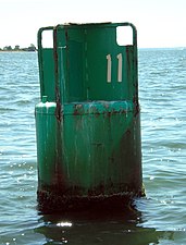 Green can #11 near the mouth of the Saugatuck River.
 -
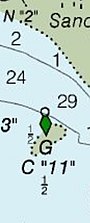 Same green can #11, on a NOAA nautical chart.
 -
-


See also
Mark types
- Lateral mark
- Cardinal mark
- Special mark
- Safe water mark
- Isolated danger mark
- Leading lights
- Emergency wreck buoy
Other
- Buoy
- Lightvessel
- Lighthouse
- Landmark
- Daymark
- Racon
- ATON
References
- ^ "Ashey Down Sea Mark, Havenstreet and Ashey - 1005193 | Historic England".
- ^ Mukherjee, Paromita (January 8, 2021). "IALA Buoyage System For Mariners – Different Types Of Marks". Marine Insight. Retrieved 2021-03-08.
- ^ "IALA Maritime Buoyage System". IALA. Archived from the original on 2010-03-17.
Cardinal, isolated, safewater, special marks, new dangers, regions A and B
- ^ "IALA Maritime Buoyage System". Nautical Issues. 26 June 2023.
| Types |
| _-_cropped.jpg) | ||||
|---|---|---|---|---|---|---|
| Fixtures | ||||||
| Maintenance | ||||||
| Locations | ||||||
| Categories | ||||||
| Global organizations | ||||||