
Sellingen
Sellingen | ||
|---|---|---|
Postal code 9551 | ||
| Dialing code | 0599 | |
Sellingen (Dutch pronunciation:
Overview
Sellingen was founded in the 12th century on a sandy ridge along the River Ruiten Aa. The church dates from the 1300s,[3] however a church in Sellingen was already mentioned around 1150 on a list of possession of the Diocese of Osnabrück.[4]: 30 In the 15th century, the Ter Apel Monastery was part of the parish of Sellingen.[5]
In 1665, the
Around 1750, the first school was built in Sellingen.[6] In October 1964, a road was opened between Sellingen and Walchum. Despite protests by both municipalities, the border remained fenced off, because Germany did not want to establish a border post.[7]
Sellingen used to be part of the municipality of Bourtange. In 1821, it became part of Vlagtwedde.[4]: 9 Many people desired a more central location of the municipal council. In 1889, the council voted to move the seat to Sellingen.[4]: 11 In 2017, Vlagtwedde merged into Westerwolde, however Sellingen is still one of the two seats.[6]
Nature
There was still a
The Hasseberg is located near the German border, and is the highest point in Groningen at 14.6 metres (48 ft).[10]
Notable people
- Geert Meijer (born 1951), footballer[11]
- Anke de Vries (born 1936), children's book author[12]
Gallery
-
 Municipal council
 -
 Hasseberg
 -
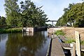 Sellingen (2018)
 -
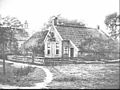 Sellingen (1927 or 28)


References
- ^ a b c "Kerncijfers wijken en buurten 2021". Central Bureau Statistics. Retrieved 28 February 2022.
- ^ "Postcodetool for 9551AA". Actueel Hoogtebestand Nederland (in Dutch). Het Waterschapshuis. Retrieved 1 March 2022.
- ISBN 90-400-9258-3. Retrieved 1 March 2022.
- ^ a b c d J. Engelkes (1936). Gids voor Vlagtwedde. Sellingen.
{{cite book}}: CS1 maint: location missing publisher (link) - ^ "De Kerk te Sellingen" (in Dutch). 25 June 1927. Retrieved 1 March 2022.
- ^ a b "Sellingen". Plaatsengids (in Dutch). Retrieved 1 March 2022.
- ^ "Geen autoverkeer over nieuwe verbinding Nederland-Duitsland". Gereformeerd gezinsblad (in Dutch). 10 October 1964. Retrieved 1 March 2022.
- ^ "Bossen in Westerwolde" (in Dutch). Retrieved 1 March 2022.
- ^ "Sellingerbossen". Vlinderstichting (in Dutch). Retrieved 1 March 2022.
- ^ "Hasseberg". Canon van Nederland (in Dutch). Retrieved 1 March 2022.
- ^ "Geert Meijer". Newcastle Fans. Retrieved 1 March 2022.
- ^ Eefje Buenen (2014). Anke de Vries (in Dutch). pp. 1–7. Retrieved 1 March 2022.
External links
 Media related to Sellingen at Wikimedia Commons