
Serra do Caramulo
| Serra do Caramulo | |
|---|---|
.jpg) | |
| Highest point | |
| Peak | Caramulinho |
| Elevation | 1,076.57 m (3,532.1 ft)[1] |
| Coordinates | 40°34′49.6″N 8°10′35″W / 40.580444°N 8.17639°W |
| Geography | |
 Serra do Caramulo | |
| Country | Centro |
| Geology | |
| Type of rock | Granite, Schist[1] |
Serra do Caramulo is a mountain range in
espigueiros typical of this region. Some traces of Neolithic and Roman occupation, such as the megaliths and stone tracks, can still be found in the range. It has a rich flora, predominated by Genista tridentata and heather and also the rare Rhododendron ponticum.[1][2]
The Caramulinho is the highest peak of the range where the Atlantic Ocean and Serra da Estrela are visible in the clearest days.[1]
The small locality of Caramulo is also part of the range.[2]
Climate
The range has a
warm-summer Mediterranean climate (Köppen: Csb, Thornthwaite: AB1'ra'), with warm, dry summers and cool, rainy winters.[3][4]
| Climate data for Serra do Caramulo, altitude: 810 m (2,660 ft), 1961-1990 normals and extremes | |||||||||||||
|---|---|---|---|---|---|---|---|---|---|---|---|---|---|
| Month | Jan | Feb | Mar | Apr | May | Jun | Jul | Aug | Sep | Oct | Nov | Dec | Year |
| Record high °C (°F) | 17.1 (62.8) |
18.8 (65.8) |
22.6 (72.7) |
26.2 (79.2) |
31.5 (88.7) |
34.8 (94.6) |
36.4 (97.5) |
36.8 (98.2) |
35.8 (96.4) |
30 (86) |
23.6 (74.5) |
20.0 (68.0) |
36.8 (98.2) |
| Mean daily maximum °C (°F) | 9.2 (48.6) |
9.9 (49.8) |
11.9 (53.4) |
13.7 (56.7) |
16.7 (62.1) |
21.0 (69.8) |
24.6 (76.3) |
24.7 (76.5) |
22.4 (72.3) |
17.2 (63.0) |
12.2 (54.0) |
9.8 (49.6) |
16.1 (61.0) |
| Daily mean °C (°F) | 6.2 (43.2) |
6.8 (44.2) |
8.2 (46.8) |
9.7 (49.5) |
12.5 (54.5) |
16.4 (61.5) |
19.5 (67.1) |
19.5 (67.1) |
17.8 (64.0) |
13.7 (56.7) |
9.1 (48.4) |
6.8 (44.2) |
12.2 (53.9) |
| Mean daily minimum °C (°F) | 3.2 (37.8) |
3.6 (38.5) |
4.5 (40.1) |
5.7 (42.3) |
8.2 (46.8) |
11.8 (53.2) |
14.3 (57.7) |
14.3 (57.7) |
13.3 (55.9) |
10.1 (50.2) |
6.0 (42.8) |
3.9 (39.0) |
8.2 (46.8) |
| Record low °C (°F) | −4.8 (23.4) |
−4.2 (24.4) |
−4.5 (23.9) |
−2.0 (28.4) |
0.9 (33.6) |
3.6 (38.5) |
6.9 (44.4) |
7.0 (44.6) |
4.5 (40.1) |
1.4 (34.5) |
−3.6 (25.5) |
−7.3 (18.9) |
−7.3 (18.9) |
| Average precipitation mm (inches) | 377.1 (14.85) |
374.0 (14.72) |
219.5 (8.64) |
179.8 (7.08) |
151.2 (5.95) |
94.3 (3.71) |
24.0 (0.94) |
21.9 (0.86) |
94.2 (3.71) |
214.9 (8.46) |
283.4 (11.16) |
303.0 (11.93) |
2,337.3 (92.01) |
| Average precipitation days (≥ 0.1 mm) | 16.3 | 15.3 | 14.2 | 13.6 | 11.6 | 8.4 | 3.9 | 4.0 | 7.6 | 11.9 | 14.8 | 13.8 | 135.4 |
| Average snowy days | 1.0 | 0.9 | 0.7 | 0.3 | 0.5 | 0 | 0 | 0 | 0 | 0 | 0.1 | 0.7 | 4.2 |
| Average relative humidity (%)
|
82.5 | 80.0 | 73.5 | 73.5 | 72 | 69 | 61 | 61 | 67.5 | 75 | 80.5 | 81.5 | 73.1 |
| Mean monthly sunshine hours | 104 | 132 | 168 | 206 | 250 | 266 | 323 | 316 | 214 | 177 | 132 | 128 | 2,416 |
| Source: | |||||||||||||
| Climate data for Serra da Muna, altitude: 628 m (2,060 ft), 1961-1990 normals and extremes | |||||||||||||
|---|---|---|---|---|---|---|---|---|---|---|---|---|---|
| Month | Jan | Feb | Mar | Apr | May | Jun | Jul | Aug | Sep | Oct | Nov | Dec | Year |
| Record high °C (°F) | — | — | — | — | — | — | — | 38.7 (101.7) |
— | — | — | — | 38.7 (101.7) |
| Mean daily maximum °C (°F) | 10.4 (50.7) |
11.4 (52.5) |
13.7 (56.7) |
15.5 (59.9) |
19.0 (66.2) |
23.4 (74.1) |
27.0 (80.6) |
27.3 (81.1) |
24.6 (76.3) |
18.9 (66.0) |
13.6 (56.5) |
10.7 (51.3) |
18.0 (64.3) |
| Daily mean °C (°F) | 6.7 (44.1) |
7.4 (45.3) |
9.1 (48.4) |
10.6 (51.1) |
13.5 (56.3) |
17.4 (63.3) |
20.2 (68.4) |
20.2 (68.4) |
18.5 (65.3) |
14.2 (57.6) |
9.7 (49.5) |
7.1 (44.8) |
12.9 (55.2) |
| Mean daily minimum °C (°F) | 3.0 (37.4) |
3.5 (38.3) |
4.4 (39.9) |
5.6 (42.1) |
8.0 (46.4) |
11.4 (52.5) |
13.3 (55.9) |
13.1 (55.6) |
12.5 (54.5) |
9.5 (49.1) |
5.8 (42.4) |
3.6 (38.5) |
7.8 (46.1) |
| Record low °C (°F) | — | — | — | — | — | — | — | — | — | — | — | −7.0 (19.4) |
−7.0 (19.4) |
| Average relative humidity (%) (at 9:00 AM)
|
85 | 83 | 75 | 73 | 71 | 68 | 65 | 63 | 68 | 76 | 81 | 85 | 74 |
| Source: Instituto de Meteorologia[5]
| |||||||||||||
-
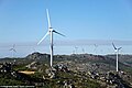 Wind farm
 -
 View of the range
 -
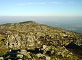 View from Caramulinho
 -
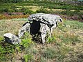 Malhada do Cambarinho Dolmen
.jpg)
.jpg)
.jpg)

References
- ^ a b c d "Serra do Caramulo". Turismo Centro Portugal (in Portuguese). Retrieved 15 May 2021.
- ^ a b "Caramulo". www.visitportugal.com (in European Portuguese). Retrieved 15 May 2021.
- ^ a b "Plano Diretor Municipal de Tondela". Tondela Municipality. Retrieved 19 June 2021.
- ^ a b "Caracterização Física de Tondela". Câmara Municipal de Tondela. Retrieved 27 September 2021.
- ^ a b "Plano de Gestão das Bacias Hidrográficas dos rios Vouga, Mondego e Lis Integrados na Região Hidrográfica 4" (PDF). Administração da Região Hidrográfica do Centro. Retrieved 7 July 2021.
This Portugal location article is a stub. You can help Wikipedia by expanding it. |
This Europe mountain, mountain range, or peak related article is a stub. You can help Wikipedia by expanding it. |