
Slieve Croob
| Slieve Croob | |
|---|---|
| Sliabh Crúibe | |
Marilyn | |
| Coordinates | 54°20′24″N 5°58′25″W / 54.340088°N 5.973671°W |
| Naming | |
| English translation | mountain of the hoof |
| Language of name | Irish |
| Geography | |
 Slieve Croob shown within Northern Ireland | |
| Location | County Down, Northern Ireland |
| Parent range | Dromara Hills |
| OSI/OSNI grid | J318453 |
Slieve Croob (from
River Lagan. There is a small road to the summit, where there is an ancient burial cairn and several transmitter stations with radio masts
. It has wide views over all of County Down and further afield. The Dromara Hills also includes Slievenisky, Cratlieve, Slievegarran and Slievenaboley.
Slieve Croob may have been the mountain named Brí Erigi or Brí Airige in medieval writings.bilberries and there would be folk music, dancing and games.[8]
Local people still climb the mountain on the first Sunday in August (referred to as Cairn Sunday or Blaeberry Sunday), and carry a stone up the mountain to help bury the twelve Kings, who are said to be buried at the top.[9]
Gallery
-
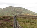 Slieve Croob from Slievenisky
 -
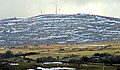 Slieve Croob from the west, covered with patches of snow
 -
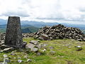 The summit, looking towards the Mournes
 -
 Communications towers on Slieve Croob

_-_geograph.org.uk_-_1739100.jpg)


References
- ISBN 978-0-19-960908-6. Retrieved 20 January 2009.
- ^ "Slieve Croob at MountainViews.ie". Archived from the original on 12 August 2021. Retrieved 26 September 2021.
- ^ a b Slieve Croob at Place Names NI Archived 2020-09-30 at the Wayback Machine.
- ^ ISBN 978-0-9567278-6-2. Archivedfrom the original on 10 August 2021. Retrieved 26 September 2021.
- ^ Philip Dixon Hardy. The Northern Tourist; Or, Stranger's Guide to the North and North West of Ireland. Curry, 1830. p.70
- ^ Sarah Champion & Gabriel Cooney. "Chapter 13: Naming the Places, Naming the Stones". Archaeology and Folklore. Routledge, 2005. p.193
- ^ Doherty, Gillian. The Irish Ordnance Survey: History, Culture and Memory. Four Courts Press, 2004. p.89
- ISBN 978-0-9567278-6-2. Archivedfrom the original on 10 August 2021. Retrieved 26 September 2021.
- ^ "Twelve Kings Challenge SUNDAY 16th JUNE 2019 starting at 09:30".
- ^ "Banbridge". Travel Now. Archived from the original on 28 September 2007. Retrieved 11 December 2007.
Mountains and hills of Ulster | ||
|---|---|---|
| Antrim Hills |  | |
| Belfast Hills | ||
| Blue Stacks | ||
| Derryveagh | ||
| Inishowen | ||
| Keenaght Hills | ||
| Mournes | ||
| Sperrins | ||
| Southwest Donegal | ||
| Others | ||