Sololá Department
You can help expand this article with text translated from the corresponding article in Spanish. (January 2023) Click [show] for important translation instructions.
|
Sololá Department
Departmento de Sololá | |
|---|---|
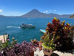
 View of Volcán Atitlán | |
|
UTC-6 | |
| ISO 3166 code | GT-SO |

Sololá is a
Lake Atitlan
is a key feature surrounded by a number of the municipalities.
Municipalities
- Concepción
- Nahualá
- Panajachel
- San Andrés Semetabaj
- San Antonio Palopó
- San José Chacayá
- San Juan La Laguna
- San Lucas Tolimán
- San Marcos La Laguna
- San Pablo La Laguna
- San Pedro La Laguna
- Santa Catarina Ixtahuacan
- Santa Catarina Palopó
- Santa Clara La Laguna
- Santa Cruz La Laguna
- Santa Lucía Utatlán
- Santa María Visitación
- Santiago Atitlán
- Sololá
Population
As of 2018, the department had a population of 421,583.
Economy
With fertile
cherries, cherimoya, peaches, and pears. Livestock is also common, including sheep. Since 1850, the region has had a large wool industry.[2]
Ecology
The area is
Lago de Atitlán
is located in Sololá.
Sports
Saprissa de Guatemala is Solola's main football team and the most famous club in the department.
Geography
Sololá has an area of 1,061 km²
References
- ^ a b Citypopulation.de Population of departments in Guatemala
- ^ a b c Baily, John (1850). Central America; Describing Each of the States of Guatemala, Honduras, Salvador, Nicaragua, and Costa Rica. London: Trelawney Saunders. pp. 80–83.
- ^ a b c d "CARACTERIZACIÓN" (PDF). Ine.gob.gt. Retrieved 14 October 2017.

