
South Bloomfield, Ohio
South Bloomfield, Ohio | ||
|---|---|---|
FIPS code 39-73068[4] | | |
| GNIS feature ID | 2399843[3] | |
| Website | http://www.southbloomfieldoh.com/ | |
South Bloomfield is a
History
The town was originally laid out in 1803. General James Denny was originally contracted to survey the area, embracing 40 acres and divided into 80 lots. The founding members in the area had initially hoped that this would eventually be the county seat, but time and politics worked against this idea.[6]
South Bloomfield was once the Puppetry Capital of America.[7]
Geography
According to the United States Census Bureau, the village has a total area of 4.28 square miles (11.09 km2), all land.[8]
Demographics
| Census | Pop. | Note | %± |
|---|---|---|---|
| 1870 | 283 | — | |
| 1880 | 303 | 7.1% | |
| 1890 | 272 | −10.2% | |
| 1900 | 222 | −18.4% | |
| 1910 | 212 | −4.5% | |
| 1920 | 230 | 8.5% | |
| 1930 | 235 | 2.2% | |
| 1940 | 238 | 1.3% | |
| 1950 | 250 | 5.0% | |
| 1960 | 424 | 69.6% | |
| 1970 | 610 | 43.9% | |
| 1980 | 934 | 53.1% | |
| 1990 | 900 | −3.6% | |
| 2000 | 1,179 | 31.0% | |
| 2010 | 1,744 | 47.9% | |
| 2020 | 2,143 | 22.9% | |
| U.S. Decennial Census[9] | |||
2010 census
As of the
There were 654 households, of which 41.9% had children under the age of 18 living with them, 52.4% were married couples living together, 14.4% had a female householder with no husband present, 5.5% had a male householder with no wife present, and 27.7% were non-families. 21.9% of all households were made up of individuals, and 9.4% had someone living alone who was 65 years of age or older. The average household size was 2.67 and the average family size was 3.02.
The median age in the village was 34.3 years. 28.1% of residents were under the age of 18; 8% were between the ages of 18 and 24; 30.5% were from 25 to 44; 23.3% were from 45 to 64; and 10.1% were 65 years of age or older. The gender makeup of the village was 48.9% male and 51.1% female.
2000 census
As of the
There were 473 households, out of which 36.4% had children under the age of 18 living with them, 56.2% were married couples living together, 12.5% had a female householder with no husband present, and 26.6% were non-families. 22.6% of all households were made up of individuals, and 8.9% had someone living alone who was 65 years of age or older. The average household size was 2.49 and the average family size was 2.90.
In the village, the population was spread out, with 27.0% under the age of 18, 9.2% from 18 to 24, 29.0% from 25 to 44, 24.0% from 45 to 64, and 10.8% who were 65 years of age or older. The median age was 34 years. For every 100 females there were 94.9 males. For every 100 females age 18 and over, there were 88.0 males.
The median income for a household in the village was $36,927, and the median income for a family was $39,853. Males had a median income of $32,344 versus $24,583 for females. The
Education
South Bloomfield is served by the Teays Valley Local School District.
In the media
South Bloomfield is featured in the Together Concepts video production "We Are... Teays Valley". The video depicts numerous achievements and innovations, as well as connections to American and world history.[11]
Gallery
-
 South Bloomfield corporation limit sign
 -
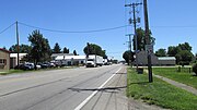 Looking south on North Walnut Street (US Highway 23) in South Bloomfield
 -
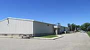
 Krazy Kats Pay Lake
 -
 Rick Brown Memorial VFW Post 7941
 -
 South Bloomfield United Methodist Church
 -
 South Bloomfield Water Tower
 -
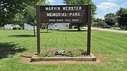 Marvin Webster Memorial Park
 -
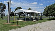 Marvin Webster Memorial Park


References
- ^ "South Bloomfield Mayor". Retrieved December 13, 2022.
- ^ "ArcGIS REST Services Directory". United States Census Bureau. Retrieved September 20, 2022.
- ^ a b U.S. Geological Survey Geographic Names Information System: South Bloomfield, Ohio
- ^ a b "U.S. Census website". United States Census Bureau. Retrieved January 31, 2008.
- ^ "Commercial Point outgrows Circleville". Circleville Online. July 9, 2019. Retrieved July 9, 2019.
- ^ Village History
- ^ Hines, Bob, 2020, Amazing Ashville--The Most Colorful Community in America, Reedy Press, St. Louis, MO.
- ^ "US Gazetteer files 2010". United States Census Bureau. Archived from the original on July 2, 2012. Retrieved January 6, 2013.
- ^ "Census of Population and Housing". Census.gov. Retrieved June 4, 2015.
- ^ "U.S. Census website". United States Census Bureau. Retrieved January 6, 2013.
- ^ A New Film Sheds Light on Local Achievements
External links
 | ||||
Villages | ||||
| Townships | ||||
| CDPs | ||||
| Unincorporated communities | ||||
| Ghost town | ||||
| Footnotes | ‡This populated place also has portions in an adjacent county or counties | |||
| ||||