
St. Rose, Louisiana
St. Rose, Louisiana
Saint Rose | ||
|---|---|---|
ZIP code 70087[2] | ||
| Area code | 504 | |
| FIPS code | 22-67740 | |
Saint Rose (usually written as St. Rose) is a
2000 census, and 7,504 in 2020.[3]
History
The
dependency house, also called a garconnière (French for bachelor quarters). The property also has a preserved slave quarters building.[4]
In 1873, Palmer Elkins purchased property in St. Rose. In 1880, Elkins invited
freedman
and their families to move onto his property to receive training. He established what became known as "Elkinsville" or "Freetown".
Geography
St. Rose is located at 29°57′38″N 90°18′47″W / 29.96056°N 90.31306°W (29.960421, -90.313094).[5]
According to the United States Census Bureau, the CDP has a total area of 5.0 square miles (13.0 km2), of which 4.0 square miles (10.5 km2) is land and 1.0 square mile (2.6 km2) (19.88%) is water.
Demographics
| Census | Pop. | Note | %± |
|---|---|---|---|
| 2020 | 7,504 | — | |
| U.S. Decennial Census[6] | |||
| Race | Number | Percentage |
|---|---|---|
White (non-Hispanic)
|
3,063 | 40.82% |
Black or African American (non-Hispanic)
|
3,028 | 40.35% |
Native American
|
13 | 0.17% |
Asian
|
158 | 2.11% |
Pacific Islander
|
3 | 0.04% |
Other/Mixed
|
258 | 3.44% |
Latino
|
981 | 13.07% |
As of the 2020 United States census, there were 7,504 people, 2,914 households, and 1,905 families residing in the CDP.[7]
Education
St. Charles Parish Public School System operates public schools, including:
- St. Rose Elementary School (PK-5)
- Albert Cammon Middle School (6-8)
- Destrehan High School in Destrehan[8]
Notable people
- Macon Clark, NFL safety for the Chicago Bears
- Burnell Dent, NFL linebacker for the Green Bay Packers and New York Giants
- Snooks Eaglin, guitarist and singer
- Roy Ebron, Basketball player in the ABA
- Shelley Hennig, Miss Teen USA 2004 and actress
- Jordan Jefferson, NFL quarterback for the Tampa Bay Buccaneers
- Justin Jefferson, NFL wide receiver for the Minnesota Vikings
- Curtis Johnson, Head football coach at Tulane University and NFL assistant coach
- Beulah Levy Ledner, Dessert and pastry chef
- Ed Reed, College Football Hall of Fame and NFL Hall of Fame safety for the Baltimore Ravens, Houston Texans and New York Jets
- Darryl Richard, NFL defensive tackle for the New England Patriots
- DuSable Museum of African American History in Chicago
- Gary Tyler, who is believed to have been wrongly convicted of murder in 1974. He was released in 2016.
- Josh Victorian, NFL cornerback for the Baltimore Ravens, Detroit Lions, Houston Texans, New England Patriots, New Orleans Saints, New York Giants and Pittsburgh Steelers
- Darius Vinnett, NFL cornerback for the St. Louis Rams and Atlanta Falcons
- Michael Young Jr., NFL wide receiver for the Indianapolis Colts
Gallery
-

-
 LaBranche Plantation Dependency House historical marker
 -
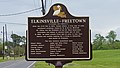 Elkinsville-Freetown historical marker

.jpg)
.jpg)
Wikimedia Commons has media related to Saint Rose, Louisiana.
References
- ^ "2020 U.S. Gazetteer Files". United States Census Bureau. Retrieved March 20, 2022.
- ^ "Saint Rose ZIP Code". zipdatamaps.com. 2022. Retrieved November 30, 2022.
- ^ "2020 Race and Population Totals". United States Census Bureau. Retrieved October 25, 2021.
- ^ "LaBranche Plantation Dependency House". experienceneworleans.com. Retrieved April 7, 2017.
- ^ "US Gazetteer files: 2010, 2000, and 1990". United States Census Bureau. February 12, 2011. Retrieved April 23, 2011.
- ^ "Census of Population and Housing". Census.gov. Retrieved June 4, 2016.
- ^ a b "Explore Census Data". data.census.gov. Retrieved December 28, 2021.
- AdvancED. p. 4. Retrieved on December 3, 2016. "The school pulls from the five communities which make up the East Bank of St. Charles Parish: Destrehan, Montz, New Sarpy, Norco, and St. Rose."
| CDPs |  | |
|---|---|---|
| Unincorporated areas | ||
| Ghost towns | ||
| Former populated places |
| |
| Footnotes | ‡This populated place also has portions in an adjacent parish or parishes | |
| ||
| International | |
|---|---|
| National | |