
Stathern
| Stathern | |
|---|---|
Leicestershire | |
| Ambulance | East Midlands |
| UK Parliament | |
Stathern is an English village and
Population
In the
Amenities
The village has an Anglican church, St Guthlac's, listed Grade II*. Parts of it date from the 13th and 17th centuries. It was restored in 1867–1868 under R. W. Johnson.[5] Guthlac of Crowland was a Lincolnshire hermit-saint of the 7th–8th century. The church has a ring of five bells. It normally holds a family service on the first Sunday in the month.[6]
The village primary school in Water Lane dates back at least to 1868 and in some form to 1845.[7] It has about 100 pupils.[8]
The public house, The Plough Inn, also acts as a restaurant and provides thrice-weekly post office services.[9] There coffee shop, village store[10] and bed-and-breakfast accommodation available in the village.[11]
Stathern is served by hourly weekday, daytime buses between Melton Mowbray and Bottesford or Bingham.[12] The nearest railway station is at Bottesford (8 miles/12.9 km), with services to and beyond Nottingham and Grantham or Skegness.
-
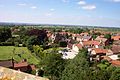
 View of Stathern looking South from the roof of St Guthlac's Church
 -
 View of Stathern looking North from the roof of St Guthlac's Church
 -
 St Guthlac's Church
 -
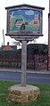
 Signpost in Stathern
 -
 Signpost in Stathern


.jpg)
.jpg)
References
- ^ "2001 Census: Key Statistics: Parish Profile – Accommodation and Tenure: Area: Stathern CP (Parish)". Neighbourhood Statistics. Office for National Statistics. Retrieved 21 November 2009.
- ^ "2001 Census: Key Statistics: Parish Headcounts: Area: Stathern CP (Parish)". Neighbourhood Statistics. Office for National Statistics. Retrieved 21 November 2009.
- ^ "Civil Parish population 2011". Neighbourhood Statistics. Office for National Statistics. Retrieved 21 June 2016.
- ^ City Population. Retrieved 3 February 2021.
- ^ Listing text. Retrieved 22 April 2019.
- ^ Stathern pages. Retrieved 22 April 2019.
- ^ School's own site. Retrieved 22 April 2019.
- ^ Ofsted reports.
- ^ Own site. Retrieved 18 April 2019.
- ^ "COFFEE SHOT | STATHERN | CAFE & SHOP". coffee-shot. Retrieved 24 February 2023.
- ^ Parish Council site. Retrieved 22 April 2019.
- ^ Bus times. Retrieved 18 April 2019.
External links
![]() Media related to Stathern at Wikimedia Commons
Media related to Stathern at Wikimedia Commons
52°52′20.2″N 0°51′15.3″W / 52.872278°N 0.854250°W
This Leicestershire location article is a stub. You can help Wikipedia by expanding it. |