
Stevinson, California
Stevinson, California | |
|---|---|
209 | |
| GNIS feature IDs | 1659870; 2583152 |
| U.S. Geological Survey Geographic Names Information System: Stevinson, California; U.S. Geological Survey Geographic Names Information System: Stevinson, California | |
Stevinson is an
The Stevinson post office opened in 1907.[5] The name honors James J. Stevinson, who bought land nearby in 1852.[5]
The town is noted for its bullring, where
The US Army built the
Geography
Stevinson is in northwestern Merced County, north of the intersection of State Routes 140 and 165. SR 140 leads east 20 miles (32 km) to Merced, the county seat, and southwest 10 miles (16 km) to Gustine, while SR 165 leads north 12 miles (19 km) to Turlock and south 19 miles (31 km) to Los Banos.
According to the United States Census Bureau, the Stevinson CDP covers an area of 1.1 square miles (2.8 km2), all of it land.[1]
Climate
This region experiences warm (but not hot) and dry summers, with no average monthly temperatures above 71.6 °F (22.0 °C). According to the
Demographics
The
The Census reported that 313 people (100% of the population) lived in households, 0 (0%) lived in non-institutionalized group quarters, and 0 (0%) were institutionalized.
There were 92 households, out of which 42 (45.7%) had children under the age of 18 living in them, 49 (53.3%) were
The population was spread out, with 95 people (30.4%) under the age of 18, 37 people (11.8%) aged 18 to 24, 82 people (26.2%) aged 25 to 44, 73 people (23.3%) aged 45 to 64, and 26 people (8.3%) who were 65 years of age or older. The median age was 28.9 years. For every 100 females, there were 118.9 males. For every 100 females age 18 and over, there were 124.7 males.
There were 101 housing units at an average density of 89.4 per square mile (34.5/km2), of which 52 (56.5%) were owner-occupied, and 40 (43.5%) were occupied by renters. The homeowner vacancy rate was 0%; the rental vacancy rate was 4.8%. 168 people (53.7% of the population) lived in owner-occupied housing units and 145 people (46.3%) lived in rental housing units.
References
- ^ a b "2022 U.S. Gazetteer Files: California". United States Census Bureau. Retrieved October 25, 2022.
- ^ a b c U.S. Geological Survey Geographic Names Information System: Stevinson, California
- ^ a b "P1. Race – Stevinson CDP, California: 2020 DEC Redistricting Data (PL 94-171)". U.S. Census Bureau. Retrieved October 25, 2022.
- ^ U.S. Geological Survey Geographic Names Information System: Stevinson, California
- ^ ISBN 1-884995-14-4.
- ^ militarymuseum.org Howard Auxiliary Field
- ^ Climate Summary for Stevinson, California
- ^ "2010 Census Interactive Population Search: CA - Stevinson CDP". U.S. Census Bureau. Archived from the original on July 15, 2014. Retrieved July 12, 2014.
Municipalities and communities of Merced County, California, United States | ||
|---|---|---|
| Cities | 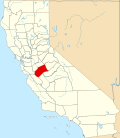 | |
| CDPs |
| |
| Unincorporated communities | ||
| Ghost towns | ||
| ||