
Stokkøya
 | |
 Stokkøya Location of the island  Stokkøya Stokkøya (Norway) | |
| Geography | |
|---|---|
| Location | Trøndelag, Norway |
| Coordinates | 64°03′48″N 9°58′50″E / 64.0632°N 09.9806°E |
| Area | 16.7 km2 (6.4 sq mi) |
| Length | 5 km (3.1 mi) |
| Width | 5 km (3.1 mi) |
| Highest elevation | 225 m (738 ft) |
| Highest point | Kamman |
| Administration | |
Norway | |
| County | Trøndelag |
| Municipality | Åfjord |
Stokkøya is an island in the municipality of Åfjord in Trøndelag county, Norway. The 16.7-square-kilometre (4,100-acre) island is located in the Stoksund area of Åfjord.[1] The largest village on the island is Harsvika. The 225-metre (738 ft) tall mountain Kamman is the highest point on the island.
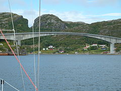
Stokkøya is connected to the mainland by the Stokkøy Bridge between the villages of Harsvika and Revsnes on the mainland. The Linesøy Bridge is being built connecting Stokkøya to the island of Linesøya to the southwest. The smaller island of Lauvøya lies about 10 kilometres (6.2 mi) to the south.[2]
Media gallery
-
 View of the island
 -
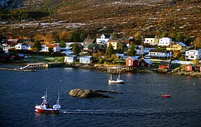
 Harsvika village
 -
 Harsvika village
 -
 Harbour buildings
 -
 Sunset on Stokkøya
 -
.jpg)


See also
References
- ^ "Stokkøya" (in Norwegian). yr.no. Retrieved 2011-01-04.
- Store norske leksikon. "Stokkøya"(in Norwegian). Retrieved 2011-01-04.
This article about an island in Trøndelag is a stub. You can help Wikipedia by expanding it. |