mean sea level.[1][2] The second-highest of the territory and the highest on the island, the Lantau Peak
, is located to its west.
Name
The
Cantonese Yale: daaih dūng shāan, Jyutping: Daai6 Dung1 Saan1) literally means "Big East Mountain".The sun sets on Sunset Peak. Viewed from Victoria Harbour
.
Access
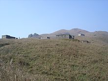
Sunset Peak is only accessible by foot. It is located on section 2 of the 70 km (43 mi) long
South Lantau Road (elevation about 120 m), to Pak Kung Au, another campsite on the Tung Chung Road (elevation about 340 m). Both campsites are served by a number of bus routes going to Mui Wo, Tung Chung, and other destinations on Lantau island.[3]