
Szerencs District
Szerencs District
Szerencsi járás | |
|---|---|
|
5th in Borsod-Abaúj-Zemplén | |
| • Density | 88/km2 (230/sq mi) |
Szerencs (
Geography
Szerencs District borders with
Municipalities
The district has 1 town, 2 large villages and 13 villages. (ordered by population, as of 1 January 2012)[1]
- Alsódobsza (319)
- Bekecs (2,391)
- Golop (523)
- Legyesbénye (1,516)
- Mád (2,128)
- Megyaszó (2,722)
- Mezőzombor (2,378)
- Monok (1,558)
- Prügy (2,348)
- Rátka (946)
- Szerencs (9,100) – district seat
- Taktaharkány (3,642)
- Taktakenéz (1,243)
- Taktaszada (1,878)
- Tállya (1,905)
- Tiszalúc (5,304)
The bolded municipality is city, italics municipalities are large villages.
Demographics
Religion in Szerencs District (2011 census)
In 2011, it had a population of 38,106 and the population density was 88/km2.
| Year | County population[2] | Change |
|---|---|---|
| 2011 | 38,106 | n/a |
Ethnicity
Besides the Hungarian majority, the main minorities are the Roma (approx. 4,000) and German (850).
Total population (2011 census): 38,106
Ethnic groups (2011 census):[3] Identified themselves: 38,709 persons:
- Hungarians: 33,893 (87.56%)
- Gypsies: 3,777 (9.76%)
- Germans: 827 (2.14%)
- Others and indefinable: 212 (0.55%)
Approx. 500 persons in Szerencs District did declare more than one ethnic group at the 2011 census.
Religion
Religious adherence in the county according to 2011 census:[4]
- Catholic – 18,124 (Roman Catholic – 16,714; Greek Catholic– 1,410);
- Reformed – 9,433;
- Evangelical – 51;
- other religions – 403;
- Non-religious – 2,083;
- Atheism – 121;
- Undeclared – 7,891.
Gallery
-
 Szerencs, the district seat
 -
 Lajos Kossuth birthplace in Monok
 -
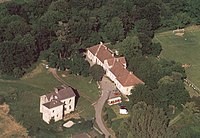 Vay Mansion in Golop
 -
 St. Stephen of Hungary Church in Tiszalúc

.jpg)


See also
- List of cities and towns of Hungary
- Szerencs Subregion (until 2013)
References
- ^ A KSH 2012. évi helységnévkönyve
- ^ népesség.com, "Szerencsi járás népessége"
- ^ 4.1.6.1 A népesség nemzetiség szerint, 2011, (in Hungarian) [1]
- ^ 4.1.7.1 A népesség vallás, felekezet szerint, 2011, (in Hungarian) [2]
External links
| Town (1) |
| |
|---|---|---|
| Large villages (2) | ||
| Villages (13) | ||
48°09′00″N 21°10′00″E / 48.1500°N 21.1667°E