Táin Way
| Táin Way | |
|---|---|
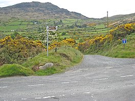
 Trail near Slieve Foy (Carlingford Mountain) | |
| Length | 40 kilometres (25 miles)[1] |
| Location | County Louth, Ireland |
| Designation | National Waymarked Trail[1] |
| Trailheads | Carlingford[1] |
| Use | Hiking |
| Elevation gain/loss | 1,025 m (3,363 ft)[1] |
| Difficulty | Moderate[1] |
| Season | all |
The Táin Way is a
It takes its name from the Táin Bó Cúailnge (English: The Cattle Raid of Cooley), a legend of early Irish literature, many of whose events take place on the Cooley peninsula.[3] The trail was devised by J. B. Malone and opened on 21 August 1986 by Liam Kavanagh, TD, Minister for Tourism, Fisheries and Forestry.[4]
The trail starts in Carlingford, climbing along the northern slopes of Slieve Foy before crossing Clermont Pass, below Clermont Carn, to reach the village of Ravensdale.[5] From Ravensdale, the route follows a ridge between Carnawaddy and Castle Mountain in the Cooley Mountains before crossing the southern flanks of Slieve Foy to return to Carlingford.[6]
A review of the National Way-marked Trails in 2010 found moderate multiday usage and high day usage on the Táin Way and recommended the development of additional looped walks off the trail and rerouting of sections on tarred roads.[2]
References
Notes
- ^ Irish Sports Council. Retrieved 1 August 2011.
- ^ a b National Trails Office 2010, p. 45.
- ^ EastWest Mapping 2008.
- ^ Stnaley, John (21 August 1986). "Legendary scenery on the Táin Trail". The Irish Times. Dublin. p. 6.
- ^ Fewer 1993, p. 179.
- ^ Fewer 1993, p. 183.
Bibliography
- EastWest Mapping (2008). Táin Way Map Guide. ISBN 978-1-899815-22-7.
- Fewer, Michael (1993). Irish Long Distance Walks. A Guide to the Way-Marked Trails. Dublin: Gill & Macmillan. ISBN 0-7171-2040-6.
- National Trails Office (2010). "Setting New Directions. A review of National Waymarked Ways in Ireland" (PDF). Dublin: Irish Sports Council. Archived from the original(PDF) on 31 May 2011. Retrieved 30 April 2011.


