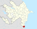
Təngərud
This article has multiple issues. Please help improve it or discuss these issues on the talk page. (Learn how and when to remove these template messages)
|
Tangerud | |
|---|---|
Municipality | |
UTC+5 (AZT) | |
| Area code | 26 |
Təngərud (also, Tengerud, Təngərüd, Tangerud, and Tangyarud) is a village and municipality in the
Astara Rayon of Azerbaijan
. It has a population of 3,298.
Etymology
Tengerud means "narrow river" in the Talysh language. The name comes from the name of the river in Tengerud. The river starts from the Talysh Mountains and flows into Caspian Sea.
Location
Tengerud is located on Baku - Astara highway. The neighborhood villages are
Masxan
. Distance between Astara city and Tengerud is 18 km, and distance between Baku city and Tengerud is 295 km. It is surrounded by the Talysh Mountains.
Demographics
Majority (~98%) of total population is Talysh. The rest of population are people from different regions of Azerbaijan and Iran.
Religion
Nearly 100% population of Tengerud is
madrasah
for religion education of the local people of Tengerud.
Education
School named after
teachers and 35 classes
in this school.
Children under age 6 attend the Tengerud kindergarten located near Tengerud Hospital.
Nature
There are more than 40 Natural Springs in Tengerud.
Transportation
There are regular time buses to Baku, Astara and Lankaran cities from Tengerud.

