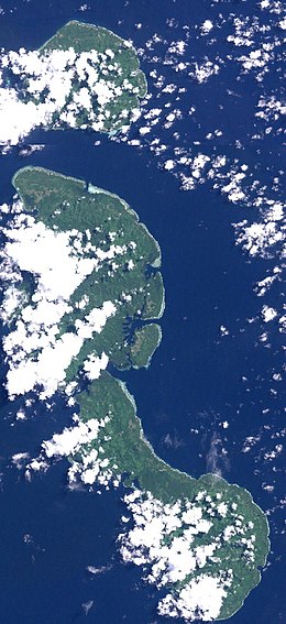
Tabar Group
 | |
| Geography | |
|---|---|
| Location | South Pacific Ocean |
| Coordinates | 2°49′S 151°57′E / 2.817°S 151.950°E |
| Archipelago | Bismarck Archipelago |
| Major islands | 3 |
| Highest elevation | 622 m (2041 ft) |
| Highest point | Mount Beirari |
| Administration | |
| Region | Islands Region |
| Province | New Ireland Province |
The Tabar Group is an island group in Papua New Guinea, located 40 km (25 mi) north of New Ireland. It is a part of the Bismarck Archipelago. The Tabar group consists of a short chain of three main islands - Tabar Island (a.k.a. Big Tabar) in the south, Tatau Island in the center, and Simberi Island in the north - as well as a number of smaller offshore islets. The highest peak is Mount Beirari at 622 m (2,041 ft).
The population of the island group was 3,920 at the 2000 Census.
The Tabar Group is the area of origin of Malagan art.[2] The local language is Mandara (also known as Tabar), ISO 639-3 language code "tbf", an Austronesian language. Three dialects have been identified, Simberi, Tatau and Tabar.[3][4]
References
- ^ PNG National Statistic Office: Census Unit Register, 2000
- ISBN 978-88-7439-369-5.
- ^ Lewis, M. Paul (ed.). "Ethnologue: Languages of the World - Mandara". SIL International. Retrieved 17 September 2010.
- ISBN 978-0-08-044854-1.
External links
- Tabar Islands auf oceandots.com at the Wayback Machine (archived December 23, 2010)

