
Taedong River
| Taedong River | |
|---|---|
South Hamgyong | |
West Korea Bay | |
| Length | 439 kilometers (273 mi)[1] |
| Basin size | 20,344 km2 (7,855 sq mi) |
| Taedong River | |
| Chosŏn'gŭl | 대동강 |
|---|---|
| Hancha | |
| Revised Romanization | Daedong-gang |
| McCune–Reischauer | Taedong-gang |
The Taedong River (
The river is 439 km or 272.7 mi in length, and is generally deep. It is the fifth-longest river on the
History
The kingdom of
The Taedong River basin is believed to be the location of the Taedonggang Culture, the historical centre of the Korean nation, when its ancient civilization flourished in 3000 BC.
Dams and bridges
In 1954, a bridge going over the Taedong River was partially destroyed during the Korean War. Despite the damage to the bridge, several hundred Koreans used it to cross the Taedong and flee south.[5] Max Desfor's photograph of the event, Flight of Refugees Across Wrecked Bridge in Korea, would win the 1951 Pulitzer Prize in Photography.[6]
In 1986, the government completed the 8-km-long
In Pyongyang, there are six bridges on the Taedong, including the
Gallery
-
 Yanggakdo Island in the middle of the river in Pyongyang
 -
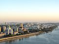
 The Taedong River flowing through Pyongyang
 -
 An image of the Taedong River from 1889
 -
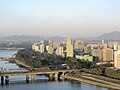
 The Taedong in Pyongyang
 -
 Another view of the river through Pyongyang
 -
 The Grand People's Study House on the bank of the river.
 -
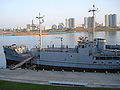 The capturedVictorious Fatherland Liberation War Museum)
 -
 The Taedong River inNampo
 -
 The river in Nampo


.jpg)


Notes
References
Citations
- ^ "Encyclopædia Britannica Online : Taedong River". Encyclopædia Britannica.
- ^ EB (1878), p. 390.
- ^ a b c Suh, Dae-Sook (1987) "North Korea in 1986: Strengthening the Soviet Connection" Asian Survey 27(1): pp. 56-63, page 62
- ^ (1973) Transactions of the Korea branch of the Royal Asiatic Society. vol. 48, page 59
- ISBN 978-0-9799521-3-5.
- ^ "Max Desfor of Associated Press". pulitzer.org. 1951. Retrieved 2020-11-25.
- ^ Tenenbaum, David J. (2005) "International Health: North Korean Catastrophe" Environmental Health Perspectives 113(1): p. A26, page A26
- ^ (209) Korea Today No. 640[permanent dead link]
- ^ "옥류교 [Okryu Bridge]", Doosan Encyclopedia, retrieved 2010-07-02[permanent dead link]
Bibliography
- , 'Encyclopædia Britannica, 9th ed., Vol. VI, New York: Charles Scribner's Sons, 1878, pp. 390–394.
See also
- Taedong River estuary Important Bird Area
- Taedonggang, a beer named after the river
- Rivers of Asia
- Rivers of Korea
- Geography of North Korea