
Tamar–Tavy Estuary
Notification 1991 | | |
| Natural England website | ||
The Tamar–Tavy Estuary is a
Geography
The 1,422-hectare (3,510-acre) SSSI encompasses the entirety of the tidal regions of the Tamar; from Gunnislake down to the Tamar Bridge in the south, where it forms the Hamoaze, and the River Tavy from Lopwell to its discharge in the Tamar. The site also includes Kingsmill Lake, Tamerton Lake and a few other tributary streams of the Tamar, as well as the marshes around Morwellham Quay.[1]
The site forms part of the Tamar Estuaries Complex Special Protection Area (SPA), along with the estuary of the River Lynher and St John's Lake,[2] as well as forming part of the Plymouth Sound and Estuaries Special Area of Conservation (SAC).[3]
The Cornwall Wildlife Trust owns the 109 hectares (270 acres) Tamar Estuary
Wildlife and ecology
The SSSI, due to its habitats, is of international importance for nature conservation, in particular as a wintering site for wildfowl and wader birds.[7]
The mudflats attract more than 20% of the British wintering population of the uncommon
The highly variable salinity along the transition from marine estuary to river allows for a diverse marine culture. Seaweeds, green algae and communities of polychaete worms are all found in the estuary system; near Calstock is found the shrimp Palaemon longirostris, which has been recorded in only two other estuaries in Britain.[7] The estuary is also one of only two sites in the UK where the fish, allis shad, spawn.[8]
Other larger animals found in undisturbed parts of the SSSI include the
Gallery
-
 River Tamar fromCalstock Viaduct
 -
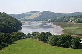 Mudflats and salt marshes on the lower reaches of the estuary system
 -
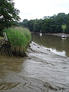
 Salt marsh on a lower bank of the River Tamar
 -
 A reedmarsh on the upper reaches of the Tamar, at Cotehele
 -
 The Lopwell Dam, a weir that is the tidal limit of the River Tavy


References
- ^ "Tamar–Tavy Estuary map". Natural England. 25 October 2011. Retrieved 9 November 2011.
- ^ "Tamar Estuaries Complex". Joint Nature Conservation Committee. 2001. Retrieved 11 November 2011.
- ^ "Plymouth Sound and Estuaries". Joint Nature Conservation Committee. Retrieved 11 November 2011.
- ISBN 978-0-319-23709-0
- ^ a b "Tamar Estuary Nature Reserve". Cornwall Wildlife Trust. Archived from the original on 27 March 2012. Retrieved 9 November 2011.
- ^ a b "Local Nature Reserves: Lopwell Dam". South West Lakes Trust. Retrieved 11 November 2011.
- ^ a b c d e "Tamar–Tavy Estuary" (PDF). Natural England. 1991. Retrieved 10 November 2011.
- ^ "Allis shad returning to Tamar estuary". BBC News Online. 12 July 2011. Retrieved 10 November 2011.
External links
![]() Media related to Tamar Estuary at Wikimedia Commons
Media related to Tamar Estuary at Wikimedia Commons
![]() Media related to Tavy Estuary at Wikimedia Commons
Media related to Tavy Estuary at Wikimedia Commons