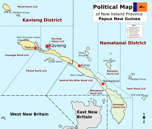
Tanir Rural LLG
Appearance
Tanir Rural LLG | |
|---|---|
UTC+10 (AEST ) |

Tanir Rural LLG is a
portmanteau
word from the two island names which are Tanga and Anir.
The current LLG president is Felix Kaltubim from
Warwar Feni language spoken on Feni Islands
.
Wards
- 01. Taonsip
- 02. Fonli
- 03. Kamunaseo
- 04. Amfar
- 05. Sungkin
- 06. Put
- 07. Nonu
- 08. Lif
- 09. Tefa
- 10. Natong/Pikan
- 11. Basakla/Fargot/Fatakasang
- 12. Warantaban/Balangkolem
- 13. Kamgot/Bulam
- 14. Balgit/Banakin/Naliu
References
- "Census Figures by Wards - Islands Region". www.nso.gov.pg. 2011 National Population and Housing Census: Ward Population Profile. Port Moresby: National Statistical Office, Papua New Guinea. 2014.
- "Final Figures". www.nso.gov.pg. 2011 National Population and Housing Census: Ward Population Profile. Port Moresby: National Statistical Office, Papua New Guinea. 2014.
- OCHA FISS (2018). "Papua New Guinea administrative level 0, 1, 2, and 3 population statistics and gazetteer". Humanitarian Data Exchange. 1.31.9.
- United Nations in Papua New Guinea (2018). "Papua New Guinea Village Coordinates Lookup". Humanitarian Data Exchange. 1.31.9.
- Foster, Robert J., Social Reproduction and History in Melanesia: Mortuary Ritual, Gift Exchange and Custom in the Tanga Islands. Cambridge: Cambridge University Press, 1995
- Hammarström, Harald; Forkel, Robert; Haspelmath, Martin; Bank, Sebastian, eds. (2016). "Tangga". Glottolog 2.7. Jena: Max Planck Institute for the Science of Human History.
- Niwer Mil (Tangga Island) at Ethnologue (18th ed., 2015)
- Warwar Feni (Feni Island) at Ethnologue (18th ed., 2015)
