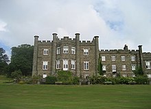
The Nunnery, Douglas

The Nunnery is an
estate outside of Douglas on the Isle of Man, named after a religious foundation on the site, at grid reference SC372754
.
The Nunnery is located on Old Castletown Road, Braddan. In 1999, the estate was acquired for the Isle of Man International Business School, now part of the University College Isle of Man.[1]
History
Monastic era

The
King Henry VIII in 1540. Nothing remains of the monastery.[2]
In 1610, the Nunnery was granted to the Earl of Derby by King James.
Post Dissolution
| Peter John Heywood's Estate Act 1776 | |
|---|---|
| Act of Parliament | |
 | |
| Long title | An Act for vesting the Settled Estates of Peter John Heywood Esquire, in the Isle of Man, called The Nunnery, in Trustees, to be sold; and for laying out the Money arising by such Sale in the Purchase of Lands and Hereditaments, in that Part of Great Britain called England, to be settled in lieu of the said Estates in the Isle of Man, intended to be sold. |
| Citation | 16 Geo. 3. c. 114 |
| Dates | |
| Royal assent | 23 May 1776 |
The buildings were acquired by Richard Calcot, Comptroller of the Isle of Man, who is said to have married the last Prioress, Margaret Goodman. The family occupied a house on the site until their descendants, the Heywoods, sold it to the Taubmans in 1776. A new mansion was built for
deconsecrated as a chapel.[4]
The mansion remained in the possession of the Taubman family:
St. John's in 2016.[5]
References
- ISBN 978-1-907945-10-6.
- ISBN 0 434 46535 6 – via Google Books.
- ^ Manx Monastic Establishments. www.isle-of-man.com.
- ^ The Nunnery, Douglas. www.isle-of-man.com.
- ^ "Culture Vannin applies for new base". Manx Radio. 30 June 2015. Archived from the original on 4 July 2015.
Sources
- David E. Easson, Medieval Religious Houses (Scotland), with an Appendix on the Houses in the Isle of Man (1957).
- Ian B. Cowan, David E. Easson, Medieval Religious Houses (Scotland), 2nd ed. (1976). ISBN 0-582-12069-1.
External links
54°08′53″N 4°29′38″W / 54.148°N 4.494°W
