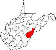
Thornwood, West Virginia
Thornwood, West Virginia | |
|---|---|
UTC-4 (EDT) | |
| Area code(s) | 304 & 681 |
| GNIS feature ID | 1555805[1] |
Thornwood is an
US Route 250 passes approximately one-half mile to the south. It is approximately 5 miles (8.0 km) east-northeast of Durbin.[2]
References
- ^ a b c U.S. Geological Survey Geographic Names Information System: Thornwood, West Virginia
- ^ Thomwood, WV, 7.5 Minute Topographic Quadrangle, USGS, 1995

